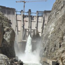
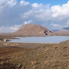
Momīn Sar, summit in Pakistan
Location: Federally Administered Tribal Areas
Elevation above the sea: 3,269 m
GPS coordinates: 32.45389,69.37611
Latest update: October 30, 2025 04:10

Forward Operating Base Chapman
112.4 km
Takht-e-Sulaiman
100.8 km
Gomal Zam Dam
61.9 km
Band E Sardeh Dam
116.5 km
Forward Operating Base Arian
147.7 km
Thal Gumbad Mosque
149.5 km
زیارت سیدمرتضی
128 km
نظرگاه سخی
128 km
Work of art
52.4 km
Scenic viewpoint
134.3 km
زیارت شاه ابوالحسن خرقانی
127.5 km
قلعه سرسنگ
128.1 km
زیارت سیداکرم آغا
128 km
زیارت شاه قمبر
128.3 km
Rehman Dheri Site
144.9 km
خاک فقیر
127.5 km
چشمه ماران
126.8 km
Bannu Woollen Mills
130.3 km
ساحه خدربابا
128 km
زیارت صالح بابا
129.2 km
زیارت خواجه کله بابا
127.7 km
زیارت سعد بن ابی وقاص
129 km
زیارت مهردل بابا
128.2 km
زیارت خواجه قیص بابا
126.3 km
زیارت سیدالف شاه بابا
127.5 km
زیارت پیران علیه رحیم
130.1 km
زیارت نورمحمدغوث پادشاه
131.1 km
Shir Khan Afghan Minar
147.7 kmReviews
Visited this place? Tap the stars to rate it and share your experience / photos with the community! Try now! You can cancel it anytime.
Discover hidden gems everywhere you go!
From secret cafés to breathtaking viewpoints, skip the crowded tourist spots and find places that match your style. Our app makes it easy with voice search, smart filtering, route optimization, and insider tips from travelers worldwide. Download now for the complete mobile experience.

A unique approach to discovering new places❞
— Le Figaro
All the places worth exploring❞
— France Info
A tailor-made excursion in just a few clicks❞
— 20 Minutes