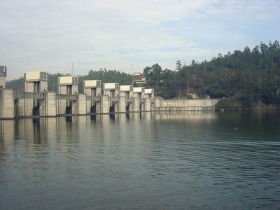
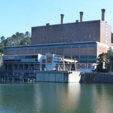
Crestuma Dam, Hydroelectric power station on Douro River, Portugal
Crestuma Dam is a concrete gravity structure that spans 470 meters across the Douro River with a height of about 26 meters. The facility includes eight spillway gates and a navigation lock to manage water and allow ships to pass through.
Construction started in 1976 and finished in 1985, representing a major step forward in Portugal's energy infrastructure at that time. The project was part of a broader effort to develop the Douro River for both power generation and river transport.
The dam connects industrial progress with river trade, as cargo vessels regularly pass through its locks on their way upstream and downstream.
The best views are from publicly accessible areas along the riverbank where you can see the structure close up. The site is easy to reach by car and works well as a quick stop on a day trip through the region.
The facility holds back a reservoir of about 110 million cubic meters of water, giving operators precise control over river levels. This stored water allows the dam to respond to seasonal changes and support both energy and navigation needs.
Location: Crestuma
Inception: 1976
Elevation above the sea: 13 m
Length: 470 m
GPS coordinates: 41.07298,-8.48676
Latest update: December 10, 2025 16:27
Mosteiro de Grijó
9.2 km
Mosteiro de Pedroso
6.2 km
Torre de Aguiar de Sousa, também designada Torre de Sousa ou Castelo de Aguiar de Sousa
7 km
Estádio de São Miguel
8.4 km
Igreja Paroquial de Gondomar
7.9 km
Sermonde
8.5 km
Solar Condes de Resende
9.4 km
Cavalete de São Vicente e instalação do Couto Mineiro
9.3 km
Capela de São Mateus de Arnelas, incluindo o património móvel integrado
3.3 km
Quinta de Baixo
7.9 km
Multiusos Gondomar Coração de Ouro
8.2 km
Antiga Central de Captação de Água da Foz do Sousa
2.8 km
Casa de São Miguel
8.6 km
Igreja Paroquial de Foz do Sousa
2.8 km
Tapada do Outeiro
2.3 km
Gondomar City Hall
9 km
Igreja Paroquial de Aguiar de Sousa
6.4 km
Igreja de São Martinho (Santa Maria da Feira)
7.2 km
Casa da Quinta de Atães
5.5 km
Castro da Senhora da Saúde
7.7 km
Casa Branca
9.4 km
Aqueduto que abastecia o Mosteiro de Grijó
9.4 km
Casa Júlio Resende
8.8 km
Tomb of D. Rodrigo Sanches
9.2 km
Grijó Municipal Stadium
9.1 km
Capela de Broalhos
2.1 km
Conjunto formado pela casa, capela, jardins e portais da Quinta da Bouça-Cova, ou dos Capuchinhos
9 km
Junta de Freguesia de Argoncilhe
7.2 kmVisited this place? Tap the stars to rate it and share your experience / photos with the community! Try now! You can cancel it anytime.
Discover hidden gems everywhere you go!
From secret cafés to breathtaking viewpoints, skip the crowded tourist spots and find places that match your style. Our app makes it easy with voice search, smart filtering, route optimization, and insider tips from travelers worldwide. Download now for the complete mobile experience.
A unique approach to discovering new places❞
— Le Figaro
All the places worth exploring❞
— France Info
A tailor-made excursion in just a few clicks❞
— 20 Minutes