Vorkuta

Log in to your account

AroundUs is a community-driven map of interesting places, built by curious explorers like you. It grows with every review, story, and photo you share.
Connect to save your favorite spots, contribute locations, and create personalized routes.
By continuing, you accept our Terms and Conditions and our Privacy Policy
Add to collection
Map
Suggest a change
Share

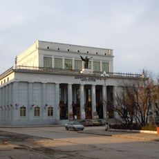
Vorkuta, Coal mining settlement north of the Arctic Circle in Komi Republic, Russia.

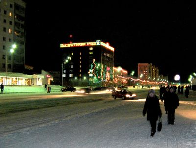
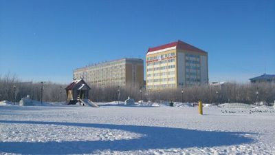
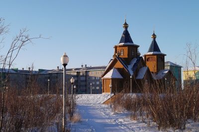
Vorkuta is a settlement in the northeastern part of the Komi Republic in Russia, located roughly 100 miles north of the Arctic Circle. The town extends along the Vorkuta River amid expansive tundra, marked by multistory residential blocks dating from the Soviet period.

The settlement was founded in 1932 as a forced labor camp and grew into a coal mining center during Soviet industrialization. After the camp system ended, the town continued to expand, reaching its largest population in the late 1980s before economic shifts led to ongoing decline.

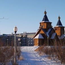
Residents adapt their daily routines to polar night in winter and midnight sun in summer, shaping how the community organizes work and leisure. Local festivals in late autumn feature reindeer sledding and traditions of indigenous northern peoples who have lived in the region for generations.

The airport links the town with other parts of Russia and remains operational even during extreme weather. Visitors should prepare for subarctic conditions, with winter temperatures often dropping below minus 22 degrees Fahrenheit (minus 30 degrees Celsius) and summer rarely exceeding 59 degrees Fahrenheit (15 degrees Celsius).

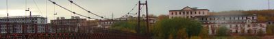
The so-called Vorkuta Ring includes several abandoned settlements and closed mines still visible around the town. Many apartment blocks stand empty after the population fell sharply since the late 1980s, leaving entire neighborhoods deserted.

Location: Vorkuta

Inception: 1932

Elevation above the sea: 180 m

Part of: Воркутинское кольцо

Website: http://воркута.рф

GPS coordinates: 67.50000,64.03333

Latest update: December 11, 2025 23:57

Photos
Around this place
Show the full map
Dvorets Kultury Shakterov
Russian Federation

Dvorets Kultury Shakterov

876 m
Orthodox cathedral of the Iveron Icon of Our Lady in Vorkuta
Russian Federation

Orthodox cathedral of the Iveron Icon of Our Lady in Vorkuta

2.3 km
Воркута - 67-я параллель
Russian Federation

Воркута - 67-я параллель

1.4 km
Перекрёсток
Russian Federation

Перекрёсток

17 km
Пешеходный подвесной мост
Russian Federation

Пешеходный подвесной мост

1.2 km
75 лет Воркутинскому механическому заводу
Russian Federation

75 лет Воркутинскому механическому заводу

1.2 km
Воркутинский драматический театр
Russian Federation

Воркутинский драматический театр

1.2 km
Государственный театр кукол Республики Коми

Государственный театр кукол Республики Коми

899 m
Дядя Федор и Почтальон печкин
Russian Federation

Дядя Федор и Почтальон печкин

1.1 km
Звездный шар
Russian Federation

Звездный шар

1.5 km
Work of art, sculpture
Russian Federation

Work of art, sculpture

1.3 km
Work of art, sculpture
Russian Federation

Work of art, sculpture

3.3 km
50 лет освоения Печорского угольного бассейна
Russian Federation

50 лет освоения Печорского угольного бассейна

1.2 km
Кирову С. М.
Russian Federation

Кирову С. М.

611 m
Ленин
Russian Federation

Ленин

1 km
Memorial
Russian Federation

Memorial

12.8 km
Узникам ГУЛАГа
Russian Federation

Узникам ГУЛАГа

707 m
Чернов
Russian Federation

Чернов

1.5 km
50 лет Стахановскому движению
Russian Federation

50 лет Стахановскому движению

3 km
Memorial
Russian Federation

Memorial

2.4 km
Ленин
Russian Federation

Ленин

13.9 km
Memorial
Russian Federation

Memorial

12.2 km
Первооткрывателям Печорского угольного бассейна
Russian Federation

Первооткрывателям Печорского угольного бассейна

443 m
Щит и меч
Russian Federation

Щит и меч

725 m
Memorial, commemorative plaque
Russian Federation

Memorial, commemorative plaque

1 km
Литовцам, погибшим в лагерях Воркуты и жертвам расстрела заключённых
Russian Federation

Литовцам, погибшим в лагерях Воркуты и жертвам расстрела заключённых

11.5 km
Погибшим при аварии на шахте Северная
Russian Federation

Погибшим при аварии на шахте Северная

11.6 km
Wayside cross
Russian Federation

Wayside cross

3.5 km
Show the full map
Reviews

Visited this place? Tap the stars to rate it and share your experience / photos with the community! Try now! You can cancel it anytime.

« Vorkuta - Coal mining settlement north of the Arctic Circle in Komi Republic, Russia » is provided by Around Us (aroundus.com). Images and texts are derived from Wikimedia project under a Creative Commons license. You are allowed to copy, distribute, and modify copies of this page, under the conditions set by the license, as long as this note is clearly visible.

Discover hidden gems everywhere you go!

From secret cafés to breathtaking viewpoints, skip the crowded tourist spots and find places that match your style. Our app makes it easy with voice search, smart filtering, route optimization, and insider tips from travelers worldwide. Download now for the complete mobile experience.

Around Us App Screenshot

A unique approach to discovering new places

Le Figaro

All the places worth exploring

France Info

A tailor-made excursion in just a few clicks

20 Minutes