Chest opened
+${chestReward.xp} XP
Explorer
NOUVEAU ×${chestReward.collectible.quantity}
tapez pour fermer

See the monuments around you in AR Open chests in the app

Around Us is built for your phone — point your camera at the streets and discover the monuments and places around you in augmented reality. Around Us is built for your phone — chests unlock when you walk, explore and capture nearby places.

Enable Location

We need your location to show you interesting places around you

Discover nearby places

Find interesting locations and hidden gems around you

Precise directions

Get accurate directions and distances to places

Your location is never shared with other users. It's only used when you tap the location button.

Log in to your account

Start exploring — it's free

Trusted by 83,982 travelers worldwide

Continue with Google
Continue with Apple
or

We will send you a code to connect

By continuing, you accept our Terms and Conditions and our Privacy Policy

Check your inbox

We've sent a pincode in your inbox. Please enter the code below.

Discussion Reviews Photo
2.1k Popularity

Вержавск, Archaeological site and fortified settlement in Demidovsky District, Russia.

Verzhavsk is a medieval fortified settlement in Demidovsky District in the Smolensk region, consisting of an earthen mound surrounded by defensive walls. The mound spans roughly 100 by 45 meters, with surrounding ramparts several meters tall that once protected the inhabitants.

The site was first documented in 1150 in Prince Rostislav's charter as an important trading post on ancient routes. The settlement remained significant until the Mongol invasions of the 13th century, which transformed the political landscape of the region.

The name reflects the settlement's roots in early medieval times when communities established themselves in this region. Daily life here revolved around commerce and family, as evidenced by the remains of dwellings and household goods scattered throughout the site.

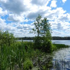
The site is located near the modern village of Gorodishche in the Smolensk region, with two lakes nearby that define the surrounding landscape. The terrain is easy to walk and the ramparts remain clearly visible, offering good views of the settlement's overall structure.

Beneath the ruins lie layers containing artifacts from the 12th and 13th centuries that reveal the settlement's prosperity as a trading hub. The quantity and quality of discovered objects indicate that residents here not only lived but actively exchanged valuable goods.

The community of curious travelers

AroundUs brings together thousands of curated places, local tips, and hidden gems, enriched daily by 60,000 contributors worldwide.

Start exploring
GPS coordinates
55.35778,31.94028
Latest update
August 4, 2026 01:22
Around this place
Bukino
Russian Federation

Bukino

4.4 km
Russian Federation

Братская могила 22 советских воинов, погибших в 1942-1943 гг.

1.6 km
Russian Federation

Братская могила 734 советских воинов

12.3 km
Russian Federation

Братская могила советских воинов

13 km
Russian Federation

Братская могила советских воинов

10.8 km
Russian Federation

Братская могила советских граждан, замученных фашистами 23.09.1942 г.

3.8 km
Russian Federation

Место первого захоронения Героя Советского Союза Володи Куриленко

11.5 km
Russian Federation

Могила 23 советских граждан, замученных фашистами 22.09.1942 г.

10.9 km
Russian Federation

Могила неизвестного партизана

10.8 km
Russian Federation

Могила советских граждан, расстрелянных фашистами в 1941 году

10.8 km
Russian Federation

Могила советского воина

13.6 km
Russian Federation

Могила юного партизана, замученного фашистами

12.8 km
Russian Federation

Могилы советских воинов, павших в боях с фашистами в 1943 г.

14 km
Russian Federation

Памятные знаки, посвященные работе выездной редакции газеты «Комсомольская правда» в тылу врага в августе 1942-1943 гг. и партизанскому соеди�

1.7 km
Russian Federation

Памятный знак в честь событий, связанных с кавалерийской группой Л.М. Доватора

10.7 km
Russian Federation

Памятный знак на месте, где в 1943 г. части Красной Армии вели упорные бои с гитлеровцами и получили название «Рибшевские»

12.7 km
Russian Federation

Обелиск, посвященный событиям Великой Отечественной войны на территории края

12.2 km
Russian Federation

Поклонный крест

3.6 km
Russian Federation

Поклонный крест

12.6 km
Russian Federation

Партизанская база

8.1 km
Russian Federation

Городище Вержавск

979 m
Russian Federation

Scenic viewpoint

954 m
Russian Federation

Памятник гражданскому населению, расстрелянному фашистами в 1942 г.

9.2 km
Russian Federation

Здание земской больницы XIX века

12.7 km
Russian Federation

Партизанские землянки

10.9 km
Russian Federation

Памятный знак Шульца

10 km
Russian Federation

Твардовский

13.7 km
Russian Federation

Памятник ВОВ

11.6 km
Show the full map
Reviews
Share your experience

No review yet

Discussions
Start a discussion...

No discussion yet

« Вержавск - Archaeological site and fortified settlement in Demidovsky District, Russia » is provided by Around Us (aroundus.com). Images and texts are derived from Wikimedia project under a Creative Commons license. You are allowed to copy, distribute, and modify copies of this page, under the conditions set by the license, as long as this note is clearly visible.

Discover hidden gems everywhere you go!

From secret cafés to breathtaking viewpoints, skip the crowded tourist spots and find places that match your style. Our app makes it easy with voice search, smart filtering, route optimization, and insider tips from travelers worldwide. Download now for the complete mobile experience.

Around Us App Screenshot

A unique approach to discovering new places

Le Figaro

All the places worth exploring

France Info

A tailor-made excursion in just a few clicks

20 Minutes

Around Us
Travel Guide & Maps
Download

Send to your phone

QR Code
1

Open the camera app on your mobile.

2

Point at the QR code with your camera. A notification will appear.

3

Tap the notification to open the link.