Chest opened
+${chestReward.xp} XP
Explorer
NOUVEAU ×${chestReward.collectible.quantity}
tapez pour fermer

See the monuments around you in AR Open chests in the app

Around Us is built for your phone — point your camera at the streets and discover the monuments and places around you in augmented reality. Around Us is built for your phone — chests unlock when you walk, explore and capture nearby places.

Enable Location

We need your location to show you interesting places around you

Discover nearby places

Find interesting locations and hidden gems around you

Precise directions

Get accurate directions and distances to places

Your location is never shared with other users. It's only used when you tap the location button.

Log in to your account

Start exploring — it's free

Trusted by 84,938 travelers worldwide

Continue with Google
Continue with Apple
or

We will send you a code to connect

By continuing, you accept our Terms and Conditions and our Privacy Policy

Check your inbox

We've sent a pincode in your inbox. Please enter the code below.

Discussion Reviews Photo
2k Popularity

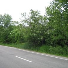
Kronstadtskoe Highway, Highway at Kotlin Island, Russia

Kronstadtskoe Highway is a road on Kotlin Island that connects the city center with outlying areas while passing historic fortified sites. It serves as a major spine structuring how different neighborhoods relate to one another.

The road was established under Peter the Great to supply fortifications protecting Saint Petersburg from invasion through the Gulf of Finland. This strategic purpose shaped its importance across following centuries.

The road connects the city center to historic military sites where monuments document the area's defensive heritage. Walking along it reveals how this route shaped local identity and remains central to how residents navigate daily life.

Local buses serve the route with several stops making it easy to access different areas. The road is relatively flat and straightforward to navigate on foot or by vehicle.

The road's final section transitions into a pedestrian path leading toward Fort Reef, a fortification with a different historical name. This shift marks where built structures give way to the natural coastline.

The community of curious travelers

AroundUs brings together thousands of curated places, local tips, and hidden gems, enriched daily by 60,000 contributors worldwide.
Start exploring
Location
Length
8 km
Part of
The Roads
GPS coordinates
60.00833,29.73472
Latest update
August 30, 2026 23:19
Around this place
Bellingshausen Cenotaph in Kronstadt
Russian Federation

Bellingshausen Cenotaph in Kronstadt

0.7 mi
Кенотаф адмирала А.И. Круза (1727-1799) (Кронштадт)
Russian Federation

Кенотаф адмирала А.И. Круза (1727-1799) (Кронштадт)

0.7 mi
Казарма (Кронштадт)
Russian Federation

Казарма (Кронштадт)

0.2 mi
Траверс (Кронштадт)
Russian Federation

Траверс (Кронштадт)

0.6 mi
Barracks of Kronstadt Fortress Miners
Russian Federation

Barracks of Kronstadt Fortress Miners

0.2 mi
Офицерское собрание и канцелярия (Кронштадт)
Russian Federation

Офицерское собрание и канцелярия (Кронштадт)

0.2 mi
Кенотаф адмирала Р.Н. Вирена (1857-1917) (Кронштадт)
Russian Federation

Кенотаф адмирала Р.Н. Вирена (1857-1917) (Кронштадт)

0.7 mi
Казарма для офицеров (Кронштадт)
Russian Federation

Казарма для офицеров (Кронштадт)

0.2 mi
Казарма для младших офицеров (Кронштадт)
Russian Federation

Казарма для младших офицеров (Кронштадт)

0.3 mi
Ледник (Кронштадт)
Russian Federation

Ледник (Кронштадт)

0.2 mi
Парк (Кронштадт)
Russian Federation

Парк (Кронштадт)

0.4 mi
Братская могила мирных жителей г. Кронштадта, погибших в Великую Отечественную войну (Кронштадт)
Russian Federation

Братская могила мирных жителей г. Кронштадта, погибших в Великую Отечественную войну (Кронштадт)

0.7 mi
Пороховой погреб (Кронштадт)
Russian Federation

Пороховой погреб (Кронштадт)

0.7 mi
Lunette 'Admiral Litke'
Russian Federation

Lunette 'Admiral Litke'

0.5 mi
Служебный корпус (Кронштадт)
Russian Federation

Служебный корпус (Кронштадт)

0.3 mi
Russian Federation

Старый склад

0.5 mi
Russian Federation

Пороховой погреб (1895г.)

0.5 mi
Russian Federation

Дача А.В. Верещагина (1893)

0.4 mi
Russian Federation

Старый кирпичный дом

0.5 mi
Russian Federation

Старый бетонный пороховой бункер

0.2 mi
Russian Federation

Бетонный погреб (ХIX век)

0.3 mi
Russian Federation

Пороховой погреб

0.7 mi
Russian Federation

Мемориал морякам-катерникам Балтики

0.7 mi
Russian Federation

Кенотаф Фаддея Фаддеевича Беллинсгаузена

0.7 mi
Russian Federation

Братская могила мирных жителей Кронштадта

0.7 mi
Russian Federation

Кенотаф адмирала фон Круза

0.7 mi
Russian Federation

Могила детей, умерших в блокаду

0.7 mi
Russian Federation

Ruins

0.6 mi
Show the full map
Reviews
Share your experience

No review yet

Discussions
Start a discussion...

No discussion yet

« Kronstadtskoe Highway - Highway at Kotlin Island, Russia » is provided by Around Us (aroundus.com). Images and texts are derived from Wikimedia project under a Creative Commons license. You are allowed to copy, distribute, and modify copies of this page, under the conditions set by the license, as long as this note is clearly visible.

Discover hidden gems everywhere you go!

From secret cafés to breathtaking viewpoints, skip the crowded tourist spots and find places that match your style. Our app makes it easy with voice search, smart filtering, route optimization, and insider tips from travelers worldwide. Download now for the complete mobile experience.

Around Us App Screenshot

A unique approach to discovering new places

Le Figaro

All the places worth exploring

France Info

A tailor-made excursion in just a few clicks

20 Minutes

Around Us
Travel Guide & Maps
Download

Send to your phone

QR Code
1

Open the camera app on your mobile.

2

Point at the QR code with your camera. A notification will appear.

3

Tap the notification to open the link.