Kykula, mountain
Location: District of Kysucké Nové Mesto
GPS coordinates: 49.32467,18.89277
Latest update: November 6, 2025 08:02

Ľadonhora
4.9 km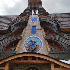
Slovak Astronomical Clock in Stará Bystrica
4 km
Černatin
1.5 km
Holý vrch
4.9 km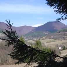
Ľadonhora
4.7 km
Priehyb
949 m
Saint Michael Archangel (Stará Bystrica)
4 km
Obelec
2.6 km
Socha sv. Jána Nepomuckého
4.1 km
Prícestný kríž, socha
3.5 km
Ľudový dom
2.9 km
Ľudový dom
3 km
Marusov Vrch
4.5 km
Prícestný kríž, podstavec
3.5 km
Roľnícka usadlosť
3.6 km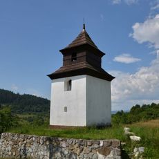
Zvonica
2.7 km
Prícestný kríž, kríž s korpusom
3.5 km
Prícestný kríž, reliéf II.
3.5 km
Prícestný kríž, reliéf I.
3.5 km
Ľudový dom
3.2 km
Bobovec observation tower
4.3 km
Včelnica Kašička
4.5 km
Slovenský orloj
4 km
Village in a valley
4.1 km
Work of art, sculpture
4 km
Work of art, sculpture
4.1 km
Zbojnícka bašta
4.1 km
Vadičovský vodopád
4.2 kmReviews
Visited this place? Tap the stars to rate it and share your experience / photos with the community! Try now! You can cancel it anytime.
Discover hidden gems everywhere you go!
From secret cafés to breathtaking viewpoints, skip the crowded tourist spots and find places that match your style. Our app makes it easy with voice search, smart filtering, route optimization, and insider tips from travelers worldwide. Download now for the complete mobile experience.

A unique approach to discovering new places❞
— Le Figaro
All the places worth exploring❞
— France Info
A tailor-made excursion in just a few clicks❞
— 20 Minutes