Nam Tok Pang Sawan, Wasserfall in Thailand
Location: Uthai Thani
Elevation above the sea: 514 m
GPS coordinates: 15.22444,99.40139
Latest update: November 13, 2025 06:06

Phu Toei National Park
35.7 km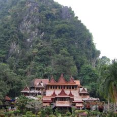
Wat Tham Khao Wong
22.2 km
Wat Ban Rai
21.2 km
Wat Khao Wong
38.9 km
Wat Salawanaram
37.4 km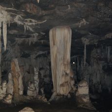
Tham Phu Wai
24.4 km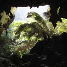
Hup Patat cave
29.8 km
Ang Kep Nam Khlong Kai Thuean
19.5 km
Ang Kep Nam Khao Khwang
38.6 km
Khao Phu I Khwai
29.8 km
Ang Kep Nam Thap Salao
35.5 km
Nam Tok Sai Boe
8.9 km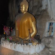
Wat Tham Thong
30 km
เขื่อนทับเสลา
36.3 km
Scenic viewpoint
29.2 km
Farmers Market Baan Rai
20.2 km
Tham Pratun Non-hunting area
31.7 km
Khao Pla Ra
30.3 km
บ้านพัก พูนสุข
22.8 km
Buddha statue
19.2 km
Wat Kok Tat
33.4 km
Scenic viewpoint
15.9 km
Scenic viewpoint
29.8 km
บ้านพุบอน Viewpoint
16.3 km
Tapernkeenoi
28.2 km
Waterfall
28.2 km
น้ำตกปางสวรรค์
2.3 km
น้ำตกผาร่มเย็น
12.6 kmReviews
Visited this place? Tap the stars to rate it and share your experience / photos with the community! Try now! You can cancel it anytime.
Discover hidden gems everywhere you go!
From secret cafés to breathtaking viewpoints, skip the crowded tourist spots and find places that match your style. Our app makes it easy with voice search, smart filtering, route optimization, and insider tips from travelers worldwide. Download now for the complete mobile experience.

A unique approach to discovering new places❞
— Le Figaro
All the places worth exploring❞
— France Info
A tailor-made excursion in just a few clicks❞
— 20 Minutes