Chest opened
+${chestReward.xp} XP
Explorer
NOUVEAU ×${chestReward.collectible.quantity}
tapez pour fermer
Chest locked

Open chests in the app

Around Us is built for your phone — chests unlock when you walk, explore and capture nearby places.

Enable Location

We need your location to show you interesting places around you

Discover nearby places

Find interesting locations and hidden gems around you

Precise directions

Get accurate directions and distances to places

Your location is never shared with other users. It's only used when you tap the location button.

Land's End Airport

Log in to your account

Start exploring — it's free

Trusted by 73,026 travelers worldwide

Continue with Google
Continue with Apple
or

We will send you a code to connect

By continuing, you accept our Terms and Conditions and our Privacy Policy

Check your inbox

We've sent a pincode in your inbox. Please enter the code below.

Discussion Reviews 1 Photos
17.5k Popularity

Land's End Airport, airport in Cornwall, England, UK

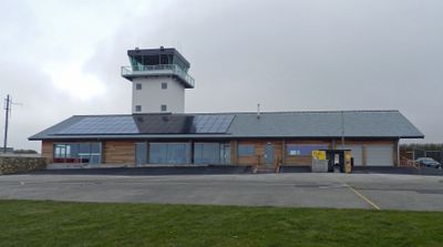
Land's End Airport is a small airport near St Just in the southwestern corner of Cornwall serving commercial flights and scenic tours. The facility features a simple terminal building positioned close to the single runway, with basic amenities designed for straightforward passenger handling and easy access between check-in and departure gates.

The airport started as a basic airstrip for small planes and gradually developed into a commercial aerodrome serving regular passenger traffic. Its growth matched rising tourism in the region and the demand for quick connections to the Isles of Scilly.

The airport's name references its proximity to Land's End, Britain's southwestern tip, and reflects the local identity of this remote coastal area. It serves as a gateway to a region deeply rooted in maritime traditions and rural heritage.

The airport is easily accessible by car, bus, or taxi, with parking facilities located close to the terminal building. Regular bus services connect the airport to nearby towns like Penzance, and taxi services are readily available for direct transfers from nearby accommodation.

The airport holds the distinction of being mainland Britain's most westerly commercial aerodrome, situated just kilometers from the iconic Land's End coastal landmark. This extreme geographic position makes it a singular gateway for exploring one of the country's most remote and dramatic coastal regions.

The community of curious travelers

AroundUs brings together thousands of curated places, local tips, and hidden gems, enriched daily by 60,000 contributors worldwide.

Start exploring
Location
GPS coordinates
50.10278,-5.67056
Latest update
February 17, 2026 06:33
Around this place
Chapel Carn Brea Tomb
United Kingdom

Chapel Carn Brea Tomb

1.3 km
Cot Mill
United Kingdom

Cot Mill

1.8 km
United Kingdom

Bridge Under B3306 Road

1.2 km
Milestone At Junction Of A30 And B3306
United Kingdom

Milestone At Junction Of A30 And B3306

1.7 km
United Kingdom

Nanjulian

1.5 km
Brea Milestone On B3306 South East Of St Just Aerodrome
United Kingdom

Brea Milestone On B3306 South East Of St Just Aerodrome

430 m
United Kingdom

Trevegean Veor Farmhouse

948 m
United Kingdom

Standing stone 200yds (180m) W of Chycarne

1.1 km
United Kingdom

The Wall Round And The Tombstone In The Quakers Burial Ground

1.7 km
United Kingdom

Brea Farmhouse

972 m
United Kingdom

Two ring cairns 110m north east of Chycarne

1.2 km
United Kingdom

Stone hut circle 390m south east of Little Brea Farm

1.1 km
United Kingdom

A kerbed cairn with cists, 450m north east of Trevedra Farm

1.3 km
United Kingdom

Round barrow 550yds (500m) N of Chycarne

943 m
United Kingdom

Wayside cross at Nanquidno Farm

1.2 km
United Kingdom

Kerbed cairn 365m north west of Tredinney

1.7 km
United Kingdom

Kerbed cairn 100m NNW of Chapel Carn Brea

1.2 km
United Kingdom

Round cairn 230m SSW of Higher Tregiffian

1.6 km
United Kingdom

Entrance grave 140m east of Kerrow

1.4 km
United Kingdom

Tin streamworks 245m south east of Higher Numphra

1.2 km
United Kingdom

Bosavern Manor House (Nursing Home)

1.6 km
United Kingdom

Bosworlas Farmhouse Cottage Adjoining Bosworlas Farmhouse

1.3 km
United Kingdom

Derelict Cottage

1.4 km
United Kingdom

Part of a prehistoric field system and medieval strip fields 250m south west of Higher Bartinney

1.4 km
United Kingdom

Stone Cross Immediately East Of Nanquidno Farmhouse

1.2 km
United Kingdom

Courtyard house settlement 335m south of Nanjulian Farm

1.5 km
United Kingdom

Crippleshill Methodist Church And Schoolroom

1.2 km
United Kingdom

Scenic viewpoint

1.3 km
Show the full map
Reviews
Share your experience

No review yet

Discussions
Start a discussion...

No discussion yet

« Land's End Airport - airport in Cornwall, England, UK » is provided by Around Us (aroundus.com). Images and texts are derived from Wikimedia project under a Creative Commons license. You are allowed to copy, distribute, and modify copies of this page, under the conditions set by the license, as long as this note is clearly visible.

Discover hidden gems everywhere you go!

From secret cafés to breathtaking viewpoints, skip the crowded tourist spots and find places that match your style. Our app makes it easy with voice search, smart filtering, route optimization, and insider tips from travelers worldwide. Download now for the complete mobile experience.

Around Us App Screenshot

A unique approach to discovering new places

Le Figaro

All the places worth exploring

France Info

A tailor-made excursion in just a few clicks

20 Minutes

Around Us
Travel Guide & Maps
Download

Send to your phone

QR Code
1

Open the camera app on your mobile.

2

Point at the QR code with your camera. A notification will appear.

3

Tap the notification to open the link.