Enable Location

We need your location to show you interesting places around you

Discover nearby places

Find interesting locations and hidden gems around you

Precise directions

Get accurate directions and distances to places

Your location is never shared with other users. It's only used when you tap the location button.

Silbury Hill

Log in to your account

Start exploring — it's free

Trusted by 61,773 travelers worldwide

Continue with Google
Continue with Apple
or

We will send you a code to connect

By continuing, you accept our Terms and Conditions and our Privacy Policy

Check your inbox

We've sent a pincode in your inbox. Please enter the code below.

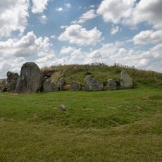
Silbury Hill, Prehistoric mound in Wiltshire, England

Description

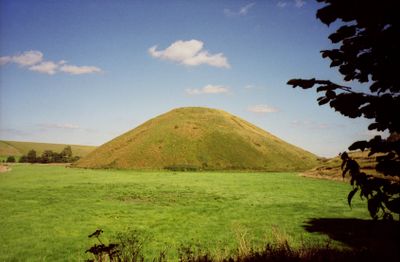
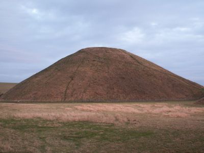
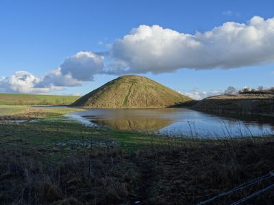
Silbury Hill is a prehistoric mound in Avebury, Wiltshire, built from layered chalk, clay, and gravel that rises to around 40 meters. Its flat summit and evenly sloped sides reflect careful planning during its construction in the Neolithic period.

History

Work began around 2660 BC and required an estimated 18 million hours of labor from roughly 700 people over ten years. Archaeologists have identified three successive building phases that gradually enlarged the mound.

Culture

The name likely derives from Old English "Seleburg" and points to an early connection with a nearby settlement. Local legends often link the mound to King Sil, a mythical ruler whose burial was believed to rest here.

Practical

A small parking area beside the A4 allows a short walk to the viewing point where the mound is clearly visible. Climbing onto the surface remains forbidden to protect the structure.

Did you know?

Early excavations in the 18th century created tunnels inside that were later filled to prevent collapse. The first phase contained wooden posts and earth before reinforced chalk walls were added.

Location
Inception
2390 BCE
Address
A4, West Kennet, Marlborough SN8 1QH, UK
GPS coordinates
51.41556,-1.85750
Latest update
December 13, 2025 19:54

AroundUs brings together thousands of curated places, local tips, and hidden gems, enriched daily by 60,000 contributors worldwide. Discover all places nearby (Avebury).

Around this place
West Kennet Long Barrow
United Kingdom

West Kennet Long Barrow

912 m
United Kingdom

South Street barrow

1.3 km
Chapel Corner Cottages
United Kingdom

Chapel Corner Cottages

1.2 km
United Kingdom

Beckhampton round barrow cemetery 150m north east of the `Waggon and Horses'

970 m
United Kingdom

Linear round barrow cemetery 200m ENE of West Kennett long barrow

1 km
Trusloe Farm Cottages
United Kingdom

Trusloe Farm Cottages

1.1 km
Waggon And Horses Public House
United Kingdom

Waggon And Horses Public House

1 km
Jasmine Cottage
United Kingdom

Jasmine Cottage

1.1 km
Butlers Cottage
United Kingdom

Butlers Cottage

1.3 km
Brow Cottage
United Kingdom

Brow Cottage

1.1 km
Milestone Approximately 460 Metres North Of Beckhampton Roundabout
United Kingdom

Milestone Approximately 460 Metres North Of Beckhampton Roundabout

1 km
United Kingdom

Dovecote At West Kennett Farm

1.1 km
Milestone Approximately 480 Metres East Of Beckhampton Roundabout
United Kingdom

Milestone Approximately 480 Metres East Of Beckhampton Roundabout

798 m
Vine Cottage
United Kingdom

Vine Cottage

1.1 km
Cartshed At West Kennett Farm
United Kingdom

Cartshed At West Kennett Farm

1.2 km
United Kingdom

Falkner's Circle

1.3 km
United Kingdom

Barns At West Kennett Farm

1.1 km
Stables With Chapel Corner Cottages
United Kingdom

Stables With Chapel Corner Cottages

1.2 km
Manor Farm House
United Kingdom

Manor Farm House

970 m
West Kennet Farmhouse
United Kingdom

West Kennet Farmhouse

1.2 km
United Kingdom

West Kennet Avenue and an earthwork bank east of West Kennett Farm

1.1 km
United Kingdom

Bowl barrow 900m SSE of Green Bank

1.2 km
Galtee More Farmhouse
United Kingdom

Galtee More Farmhouse

1 km
United Kingdom

West Kennett Farm palisaded enclosures

972 m
Milestone, cutting, E of W Kennet; 300m E of lay-by
United Kingdom

Milestone, cutting, E of W Kennet; 300m E of lay-by

739 m
United Kingdom

Wall North Of Former Farmyard Of Manor Farm House

996 m
United Kingdom

Round barrow cemetery 400m south of Avebury henge monument on Waden Hill

873 m
United Kingdom

Shrunken medieval village site E of Avebury Trusloe

1.1 km
Show the full map
« Silbury Hill - Prehistoric mound in Wiltshire, England » is provided by Around Us (aroundus.com). Images and texts are derived from Wikimedia project under a Creative Commons license. You are allowed to copy, distribute, and modify copies of this page, under the conditions set by the license, as long as this note is clearly visible.

Discover hidden gems everywhere you go!

From secret cafés to breathtaking viewpoints, skip the crowded tourist spots and find places that match your style. Our app makes it easy with voice search, smart filtering, route optimization, and insider tips from travelers worldwide. Download now for the complete mobile experience.

Around Us App Screenshot

A unique approach to discovering new places

Le Figaro

All the places worth exploring

France Info

A tailor-made excursion in just a few clicks

20 Minutes

Around Us
Travel Guide & Maps
Download

Send to your phone

QR Code
1

Open the camera app on your mobile.

2

Point at the QR code with your camera. A notification will appear.

3

Tap the notification to open the link.