Enable Location

We need your location to show you interesting places around you

Discover nearby places

Find interesting locations and hidden gems around you

Precise directions

Get accurate directions and distances to places

Your location is never shared with other users. It's only used when you tap the location button.

Carnforth

Log in to your account

Start exploring — it's free

Trusted by 62,413 travelers worldwide

Continue with Google
Continue with Apple
or

We will send you a code to connect

By continuing, you accept our Terms and Conditions and our Privacy Policy

Check your inbox

We've sent a pincode in your inbox. Please enter the code below.

Carnforth, Administrative division in Lancaster, England

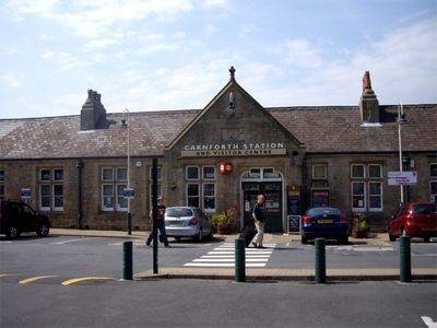
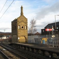
Carnforth is a railway town in Lancashire positioned where two major lines meet, connecting Barrow-in-Furness to Leeds and serving settlements across the region. The station handles regular passenger services and sits at the heart of the community as its primary transport interchange.

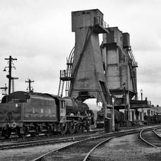
The railway arrived in the mid-1800s and transformed the area into a transport junction, with Carnforth emerging as a key stopping point between northern and central England. The station gained wider recognition during the 20th century when it was used as a filming location for a celebrated British film.

The station holds a special place in local life as both a working transport hub and a historical landmark that people in the area take pride in. Residents and visitors alike appreciate how the building connects past and present through its ongoing railway operations.

The town has a functioning shopping area with supermarkets and local services within walking distance for day-to-day needs. Most facilities are clustered near the station, making navigation straightforward for visitors arriving by train.

A diving center north of the town uses flooded former quarries and mines as training grounds for underwater instruction. This unusual repurposing of old industrial sites has made the area noteworthy for scuba enthusiasts.

The community of curious travelers

AroundUs brings together thousands of curated places, local tips, and hidden gems, enriched daily by 60,000 contributors worldwide.

Start exploring
Location
Shares border with
Over Kellet
GPS coordinates
54.12300,-2.76600
Latest update
December 20, 2025 13:56
Around this place
Carnforth MPD
United Kingdom

Carnforth MPD

1 km
Carnforth War Memorial
United Kingdom

Carnforth War Memorial

731 m
Lancaster Canal Barker's Bridge (Number 126)
United Kingdom

Lancaster Canal Barker's Bridge (Number 126)

1.3 km
Christ Church
United Kingdom

Christ Church

571 m
Roxy Cinema
United Kingdom

Roxy Cinema

678 m
Shovel Inn
United Kingdom

Shovel Inn

550 m
Lancaster Canal Kellet Lane Bridge (Number 130)
United Kingdom

Lancaster Canal Kellet Lane Bridge (Number 130)

2.2 km
Lancaster Canal Hodgson's Bridge (Number 129)
United Kingdom

Lancaster Canal Hodgson's Bridge (Number 129)

655 m
Milestone 150 Metres South Of The Junction With Alexandra Road At Ngr Sd 495 701
United Kingdom

Milestone 150 Metres South Of The Junction With Alexandra Road At Ngr Sd 495 701

468 m
Carnforth: The Coaling Plant
United Kingdom

Carnforth: The Coaling Plant

885 m
Lancaster Canal Bolton Cinder Ovens Bridge, (Number 125)
United Kingdom

Lancaster Canal Bolton Cinder Ovens Bridge, (Number 125)

1.7 km
Lancaster Canal Thwaite End Bridge (Number 127)
United Kingdom

Lancaster Canal Thwaite End Bridge (Number 127)

725 m
United Kingdom

Brookside And Brookside Cottage

1.8 km
United Kingdom

Hall Farmhouse

1.8 km
United Kingdom

Carnforth: The Ash Plant

922 m
Former Signal Box, North End Of Platform At Carnforth Station, Ngr Sd 49692 70834
United Kingdom

Former Signal Box, North End Of Platform At Carnforth Station, Ngr Sd 49692 70834

945 m
United Kingdom

Hall Garth

1.9 km
Carnforth Station Junction Signal Box
United Kingdom

Carnforth Station Junction Signal Box

1 km
United Kingdom

Keer Bridge House

1.4 km
Milestone 210 Metres North Of Junction With Hawthorn Road At Ngr Sd 485 690
United Kingdom

Milestone 210 Metres North Of Junction With Hawthorn Road At Ngr Sd 485 690

1.8 km
Milestone, Burton Road, Millhead, on bridge over River Keer, just before island for Truckhaven
United Kingdom

Milestone, Burton Road, Millhead, on bridge over River Keer, just before island for Truckhaven

1.6 km
United Kingdom

Carnforth: The Former Selside Signal Box

954 m
Village Cross, On Village Green
United Kingdom

Village Cross, On Village Green

2 km
United Kingdom

Barn To East Of Mount Pleasant Farmhouse

1.4 km
United Kingdom

Hodgson's Croft

783 m
United Kingdom

Carnforth House

692 m
United Kingdom

Plane Tree House

470 m
United Kingdom

Carnforth Station Heritage Centre

824 m
Show the full map
« Carnforth - Administrative division in Lancaster, England » is provided by Around Us (aroundus.com). Images and texts are derived from Wikimedia project under a Creative Commons license. You are allowed to copy, distribute, and modify copies of this page, under the conditions set by the license, as long as this note is clearly visible.

Discover hidden gems everywhere you go!

From secret cafés to breathtaking viewpoints, skip the crowded tourist spots and find places that match your style. Our app makes it easy with voice search, smart filtering, route optimization, and insider tips from travelers worldwide. Download now for the complete mobile experience.

Around Us App Screenshot

A unique approach to discovering new places

Le Figaro

All the places worth exploring

France Info

A tailor-made excursion in just a few clicks

20 Minutes

Around Us
Travel Guide & Maps
Download

Send to your phone

QR Code
1

Open the camera app on your mobile.

2

Point at the QR code with your camera. A notification will appear.

3

Tap the notification to open the link.