Danebury Hill Camp
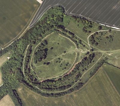
Danebury Hill Camp, Iron Age hillfort in Nether Wallop, England
Danebury Hill Camp is a circular Iron Age fort surrounded by multiple lines of earth banks and ditches for defense. The settlement covered a large area and features concentric layers of fortifications built to protect its inhabitants.
The fort was built around 550 BCE and remained occupied for approximately 500 years before being abandoned. Excavations revealed that the gateways burned multiple times, pointing to repeated attacks and military struggles.
The site reveals how people lived and worked during the Iron Age, with evidence of crafts, cooking, and religious practices that took place within its walls. Daily routines left traces that archaeologists later uncovered across the settlement.
A parking area sits near the eastern entrance, making access straightforward for visitors. From there, you can walk across the hillfort and enjoy views stretching across Hampshire and neighboring regions.
Thousands of sling stones were found at the site, showing that inhabitants prepared heavily for combat. Despite this military readiness, the fort had no natural water source, forcing residents to manage this critical challenge.
Location: Nether Wallop
Inception: 550 BCE
Website: https://hants.gov.uk/thingstodo/countryside/finder/danebury
GPS coordinates: 51.13680,-1.53970
Latest update: December 7, 2025 20:49
Army Flying Museum
2.7 km
Test Way
4.5 km
Stockbridge War Memorial
4.5 km
Old Town Hall
4.1 km
Church of St Andrew
2.3 km
Old St Peter's Church, Stockbridge
4.5 km
Church of St Peter
3.9 km
Church of St Mary
3.6 km
Vine Inn
4.3 km
Church of St Mary the Virgin
4.9 km
Dovecote In Churchyard 50 Metres North Of Chancel Of St Mary's Church
4.8 km
The Peat Spade Public House
3.7 km
White Hart
4.4 km
Fairways The Grosvenor Hotel
4.1 km
The Old Three Cups Hotel
4 km
Milestone 50 Metres East Of Side Road To Kent's Wood On Horseshoe Hill
4.5 km
Longstock War Memorial
3.7 km
Over Wallop War Memorial
4 km
Charity Farm House
3.8 km
Drovers House
3.8 km
Church Farm House
3.7 km
Waterlow
4.2 km
Milestone 800 Metres West Of Junction With Road To Houghton
2.4 km
Milestone, Windover Farm
3.7 km
Milestone 30 Metres South West Of Junction With Craydown Lane
2.8 km
Milestone, Little Dean Farm
4.6 km
Milestone, Down Farm
3.4 km
26 and 28
3.6 kmVisited this place? Tap the stars to rate it and share your experience / photos with the community! Try now! You can cancel it anytime.
Discover hidden gems everywhere you go!
From secret cafés to breathtaking viewpoints, skip the crowded tourist spots and find places that match your style. Our app makes it easy with voice search, smart filtering, route optimization, and insider tips from travelers worldwide. Download now for the complete mobile experience.
A unique approach to discovering new places❞
— Le Figaro
All the places worth exploring❞
— France Info
A tailor-made excursion in just a few clicks❞
— 20 Minutes