Badbury Rings

Log in to your account

AroundUs is a community-driven map of interesting places, built by curious explorers like you. It grows with every review, story, and photo you share.
Connect to save your favorite spots, contribute locations, and create personalized routes.
By continuing, you accept our Terms and Conditions and our Privacy Policy
Add to collection
Map
Suggest a change
Share

Badbury Rings, Iron Age hillfort in Dorset, United Kingdom

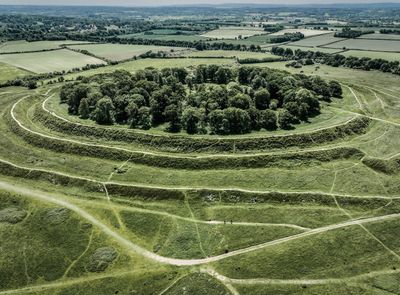
Badbury Rings is an Iron Age fort in Dorset with three concentric earthwork banks and deep ditches protecting a hilltop location. The entire structure demonstrates a carefully planned defensive design spread across open landscape.

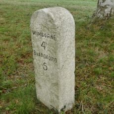
The fort was built around 500 BC and later became a strategic junction where five Roman roads converged. This location gave it military importance that lasted through many centuries.

The name comes from an Anglo-Saxon princess, and the location served as a meeting point for trade and exchange across generations. Visitors can still sense how this place connected different communities and cultures over time.

The site is accessible on foot with trails crossing the hilltop and informational signs explaining the features. Wear sturdy shoes as the ground is uneven and weather can change quickly at this elevated location.

The Romans built a temple immediately west of the fort, where excavations uncovered painted wall plaster, coins, and numerous bronze items. These findings show how deeply Roman influence had taken root at this location.

Phone: +441202883402

Email: kingstonlacy@nationaltrust.org.uk

Website: http://hiddendorset.org/index.php/hd/gem/hd1141.html

GPS coordinates: 50.82626,-2.05254

Latest update: December 7, 2025 19:31

Photos
Around this place
Show the full map
Kingston Lacy
United Kingdom

Kingston Lacy

2.2 km
Philae obelisk
United Kingdom

Philae obelisk

2.3 km
St Stephen's Church, Pamphill
United Kingdom

St Stephen's Church, Pamphill

3.2 km
St Mary the Virgin, Tarrant Crawford
United Kingdom

St Mary the Virgin, Tarrant Crawford

4.1 km
The Vine, Pamphill
United Kingdom

The Vine, Pamphill

4 km
Church of All Saints
United Kingdom

Church of All Saints

4 km
East Hemsworth Roman villa
United Kingdom

East Hemsworth Roman villa

2.9 km
Church of St Kenelm, Hinton Parva
United Kingdom

Church of St Kenelm, Hinton Parva

4.1 km
Church of St Mary the Virgin
United Kingdom

Church of St Mary the Virgin

2.9 km
Church of St Mary, Tarrant Rushton
United Kingdom

Church of St Mary, Tarrant Rushton

4.1 km
Parish Church of Saint Bartholomew
United Kingdom

Parish Church of Saint Bartholomew

3 km
176-188, Church Street
United Kingdom

176-188, Church Street

2.9 km
White Mill Bridge
United Kingdom

White Mill Bridge

2.5 km
The War Memorial
United Kingdom

The War Memorial

2.9 km
Pamphill Manor House
United Kingdom

Pamphill Manor House

3.5 km
Tarrant Keyneston War Memorial
United Kingdom

Tarrant Keyneston War Memorial

3.7 km
Footbridge Over The River Winterbourne, 200 Metres West Of King Street
United Kingdom

Footbridge Over The River Winterbourne, 200 Metres West Of King Street

3.3 km
Tarrant Crawford Cross
United Kingdom

Tarrant Crawford Cross

4.1 km
Barn Opposite White Mill
United Kingdom

Barn Opposite White Mill

2.4 km
Garden Wall 20 M South Of Kingston Lacy House
United Kingdom

Garden Wall 20 M South Of Kingston Lacy House

2.3 km
Sarcophagus 15 M South Of The Stables At Kingston Lacy House
United Kingdom

Sarcophagus 15 M South Of The Stables At Kingston Lacy House

2.3 km
Witchampton Bridge
United Kingdom

Witchampton Bridge

4.2 km
Churchyard Wall
United Kingdom

Churchyard Wall

2.9 km
Poplar Farm Including Attached Barn To North
United Kingdom

Poplar Farm Including Attached Barn To North

3.7 km
Lodge Farm House
United Kingdom

Lodge Farm House

1.3 km
Two Corinthian Capitals Approximately 60 M South Of Kingston Lacy House
United Kingdom

Two Corinthian Capitals Approximately 60 M South Of Kingston Lacy House

2.3 km
Milestone, half mile W of Badbury Rings;
United Kingdom

Milestone, half mile W of Badbury Rings;

1.3 km
Milestone, Blandford Road, 160m N of cross-roads with Station Rd, in front of Burton Lux
United Kingdom

Milestone, Blandford Road, 160m N of cross-roads with Station Rd, in front of Burton Lux

4.1 km
Show the full map
Reviews

Visited this place? Tap the stars to rate it and share your experience / photos with the community! Try now! You can cancel it anytime.

« Badbury Rings - Iron Age hillfort in Dorset, United Kingdom » is provided by Around Us (aroundus.com). Images and texts are derived from Wikimedia project under a Creative Commons license. You are allowed to copy, distribute, and modify copies of this page, under the conditions set by the license, as long as this note is clearly visible.

Discover hidden gems everywhere you go!

From secret cafés to breathtaking viewpoints, skip the crowded tourist spots and find places that match your style. Our app makes it easy with voice search, smart filtering, route optimization, and insider tips from travelers worldwide. Download now for the complete mobile experience.

Around Us App Screenshot

A unique approach to discovering new places

Le Figaro

All the places worth exploring

France Info

A tailor-made excursion in just a few clicks

20 Minutes