Chest opened
+${chestReward.xp} XP
Explorer
NOUVEAU ×${chestReward.collectible.quantity}
tapez pour fermer
Chest locked

Open chests in the app

Around Us is built for your phone — chests unlock when you walk, explore and capture nearby places.

Enable Location

We need your location to show you interesting places around you

Discover nearby places

Find interesting locations and hidden gems around you

Precise directions

Get accurate directions and distances to places

Your location is never shared with other users. It's only used when you tap the location button.

Asheville

Log in to your account

Start exploring — it's free

Trusted by 72,888 travelers worldwide

Continue with Google
Continue with Apple
or

We will send you a code to connect

By continuing, you accept our Terms and Conditions and our Privacy Policy

Check your inbox

We've sent a pincode in your inbox. Please enter the code below.

Discussion Reviews 4 Photos
54.5k Popularity

Asheville, Regional airport in Fletcher, US

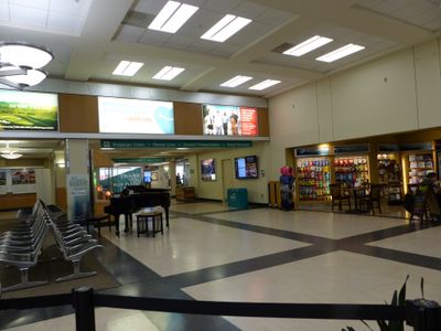
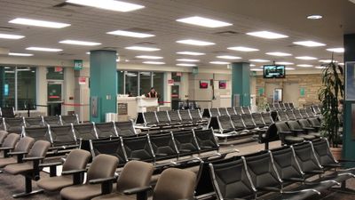
Asheville Regional Airport is a commercial airfield in Fletcher, North Carolina, serving as the main gateway to the western mountain regions of the state. The terminal features two levels with multiple security checkpoints and offers connections to major hubs along the East Coast and beyond.

The airfield began operations in the early sixties after the community needed a new site for growing regional air traffic. The facility expanded several times over the decades to accommodate larger aircraft and more travelers.

The terminal design incorporates elements from Western North Carolina landscapes, featuring natural materials and mountain-inspired architectural details.

Getting there usually involves driving along Interstate 26 or using rideshare services that take roughly thirty minutes from downtown Asheville to reach the terminal. The building offers short-term parking close by and long-term options in more distant lots served by shuttle buses.

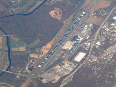
Travelers often notice the calm pace of the terminal, which remains manageable despite growing passenger numbers. The gate waiting areas offer direct views of the runway, letting you watch aircraft up close as they arrive and depart.

The community of curious travelers

AroundUs brings together thousands of curated places, local tips, and hidden gems, enriched daily by 60,000 contributors worldwide.

Start exploring
Location
Inception
January 15, 1961
Elevation above the sea
659.6 m
Operator
Asheville Regional Airport Authority
Phone
GPS coordinates
35.43611,-82.54205
Latest update
December 14, 2025 17:32
Around this place
Biltmore Estate
United States of America

Biltmore Estate

11.6 km
North Carolina Arboretum
United States of America

North Carolina Arboretum

9.1 km
Blake House
United States of America

Blake House

4.8 km
United States of America

Gunston Hall

12.4 km
The Meadows
United States of America

The Meadows

4.3 km
United States of America

Arthur W. Moore House

11 km
Rugby Grange
United States of America

Rugby Grange

2.6 km
Mills River Chapel
United States of America

Mills River Chapel

6.6 km
United States of America

Judge Junius G. Adams House

11.1 km
United States of America

Bent Creek Campus of the Appalachian Forest Experiment Station

8.9 km
United States of America

Thomas Wadley Raoul House

10.9 km
United States of America

Historic Johnson Farm

9.1 km
United States of America

Cinebarre Biltmore Square

11.9 km
United States of America

Hendersonville Outdoor Cinema

9.3 km
United States of America

Lake Julian

4.4 km
United States of America

Lake Powhatan

9.2 km
United States of America

Biltmore Forest Country Club

10.6 km
United States of America

High Vista Golf Club

3.6 km
United States of America

Broadmoor Golf Links

2.3 km
United States of America

Statue of Diana

11.5 km
United States of America

Statue, Work of art

11.6 km
United States of America

Work of art, statue

11.6 km
United States of America

Statue, Work of art

11.6 km
United States of America

Work of art, statue

11.6 km
United States of America

Statue, Work of art

11.6 km
United States of America

Bad Fork Valley Overlook

10.1 km
United States of America

View Chesnut Cove

9 km
United States of America

Bad Fork Valley Overlook (MP 399.7)

10.1 km
Show the full map
Reviews
Share your experience

No review yet

Discussions
Start a discussion...

No discussion yet

« Asheville - Regional airport in Fletcher, US » is provided by Around Us (aroundus.com). Images and texts are derived from Wikimedia project under a Creative Commons license. You are allowed to copy, distribute, and modify copies of this page, under the conditions set by the license, as long as this note is clearly visible.

Discover hidden gems everywhere you go!

From secret cafés to breathtaking viewpoints, skip the crowded tourist spots and find places that match your style. Our app makes it easy with voice search, smart filtering, route optimization, and insider tips from travelers worldwide. Download now for the complete mobile experience.

Around Us App Screenshot

A unique approach to discovering new places

Le Figaro

All the places worth exploring

France Info

A tailor-made excursion in just a few clicks

20 Minutes

Around Us
Travel Guide & Maps
Download

Send to your phone

QR Code
1

Open the camera app on your mobile.

2

Point at the QR code with your camera. A notification will appear.

3

Tap the notification to open the link.