Enable Location

We need your location to show you interesting places around you

Discover nearby places

Find interesting locations and hidden gems around you

Precise directions

Get accurate directions and distances to places

Your location is never shared with other users. It's only used when you tap the location button.

Emerald Necklace

Log in to your account

Start exploring — it's free

Trusted by 65,900 travelers worldwide

Continue with Google
Continue with Apple
or

We will send you a code to connect

By continuing, you accept our Terms and Conditions and our Privacy Policy

Check your inbox

We've sent a pincode in your inbox. Please enter the code below.

Discussion Reviews 1 Photos
40.1k Popularity

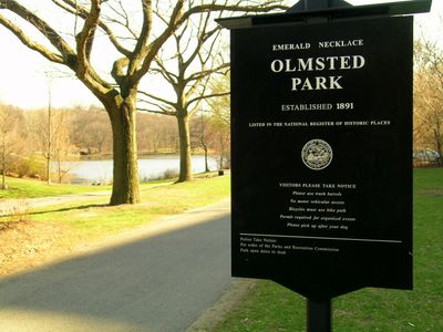
Emerald Necklace, Historic park system in Boston, United States

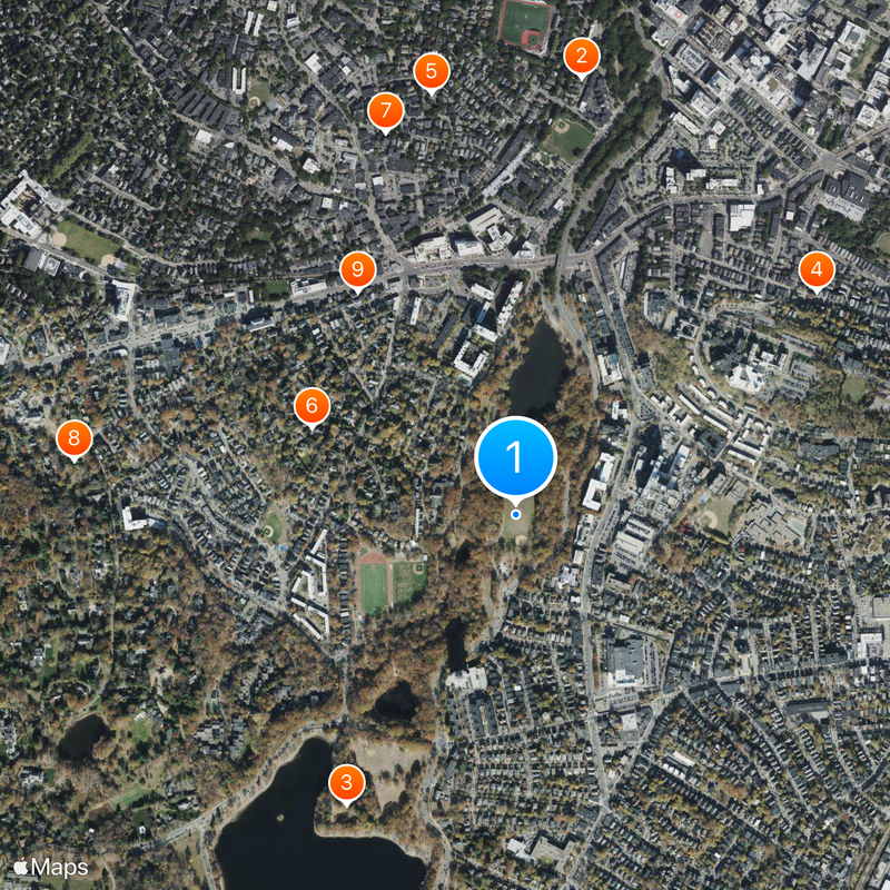
The Emerald Necklace is a connected system of nine parks, waterways, and green spaces running through Boston and Brookline. Each section links to the next through paths and waterways, forming a continuous green corridor from Boston Common to Franklin Park.

Frederick Law Olmsted began designing this park system in the late 19th century to turn waterlogged and neglected land into public green spaces. The project also addressed serious drainage issues that had long troubled the low-lying parts of the city.

The Arnold Arboretum is part of this chain and holds a large living collection of trees and shrubs that visitors can walk through freely. On weekends, the paths along the ponds and meadows fill with joggers, families, and dog walkers from nearby neighborhoods.

The park sections are spread across the city, so it helps to pick one area as a starting point rather than trying to cover everything at once. Terrain changes from one section to the next, with flat waterside paths near Jamaica Pond giving way to hillier ground in Franklin Park.

The name comes from the shape the park chain traces on a map, which resembles a necklace draped across the city. Along much of the route, walkers and cyclists can move through the corridor without crossing a single busy road.

The community of curious travelers

AroundUs brings together thousands of curated places, local tips, and hidden gems, enriched daily by 60,000 contributors worldwide.

Start exploring
Location
Location
GPS coordinates
42.32610,-71.11440
Latest update
March 10, 2026 16:55
Around this place
Timothy Hoxie House
United States of America

Timothy Hoxie House

935 m
Building at 30–34 Station Street
United States of America

Building at 30–34 Station Street

792 m
Hotel Adelaide
United States of America

Hotel Adelaide

618 m
Pill Hill Historic District
United States of America

Pill Hill Historic District

551 m
Eliphalet Spurr House
United States of America

Eliphalet Spurr House

682 m
Ginery Twitchell House
United States of America

Ginery Twitchell House

841 m
Edward H. Haskell Home for Nurses
United States of America

Edward H. Haskell Home for Nurses

589 m
Dr. Tappan Eustis Francis House
United States of America

Dr. Tappan Eustis Francis House

874 m
White Place Historic District
United States of America

White Place Historic District

556 m
House at 19 Linden Street
United States of America

House at 19 Linden Street

996 m
House at 53 Linden Street
United States of America

House at 53 Linden Street

948 m
House at 44 Linden Street
United States of America

House at 44 Linden Street

960 m
House at 38–40 Webster Place
United States of America

House at 38–40 Webster Place

883 m
United States of America

Ed Burke's

944 m
United States of America

Brendan Behan Pub

617 m
Blessed Sacrament Church
United States of America

Blessed Sacrament Church

666 m
United States of America

Ben's Circular Tower

945 m
House at 17 Cranston Street
United States of America

House at 17 Cranston Street

700 m
Connolly Branch Library
United States of America

Connolly Branch Library

679 m
House at 12 Linden Street
United States of America

House at 12 Linden Street

995 m
Brookline Village Commercial District
United States of America

Brookline Village Commercial District

976 m
United States of America

Butterflies and Plants

594 m
United States of America

Pimentel Market Mural

762 m
United States of America

Taino Mural

568 m
United States of America

Baker's Dream

843 m
United States of America

Mozart Park Mural

935 m
United States of America

Reach

939 m
United States of America

Scenic viewpoint

926 m
Show the full map
Reviews
Share your experience

No review yet

Discussions
Start a discussion...

No discussion yet

« Emerald Necklace - Historic park system in Boston, United States » is provided by Around Us (aroundus.com). Images and texts are derived from Wikimedia project under a Creative Commons license. You are allowed to copy, distribute, and modify copies of this page, under the conditions set by the license, as long as this note is clearly visible.

Discover hidden gems everywhere you go!

From secret cafés to breathtaking viewpoints, skip the crowded tourist spots and find places that match your style. Our app makes it easy with voice search, smart filtering, route optimization, and insider tips from travelers worldwide. Download now for the complete mobile experience.

Around Us App Screenshot

A unique approach to discovering new places

Le Figaro

All the places worth exploring

France Info

A tailor-made excursion in just a few clicks

20 Minutes

Around Us
Travel Guide & Maps
Download

Send to your phone

QR Code
1

Open the camera app on your mobile.

2

Point at the QR code with your camera. A notification will appear.

3

Tap the notification to open the link.