
Garrett, human settlement in DeKalb County, Indiana, United States of America
Location: DeKalb County
Elevation above the sea: 268 m
Website: http://garrettindiana.us
GPS coordinates: 41.34780,-85.13360
Latest update: March 3, 2025 11:29


Auburn Cord Duesenberg Automobile Museum
6.4 km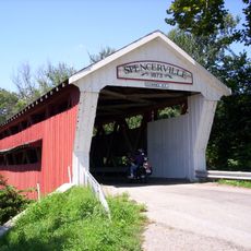
Spencerville Covered Bridge
19.8 km
Gump House
5.1 km
Garrett Historic District
304 m
Eckhart Public Library and Park
6.6 km
Downtown Auburn Historic District
6.9 km
Kendallville Downtown Historic District
15.3 km
Edward Kelham House
4.6 km
Samuel Bevier House
1.3 km
Brethren in Christ Church
3.1 km
Auburn Community Mausoleum
6.9 km
Waterloo Community Mausoleum
13.6 km
Dutch Ridge Historic District
11.2 km
Garrett Community Mausoleum
905 m
J.H. Haag House
2 km
Joseph Bowman Farmhouse
4.7 km
Henry Peters House
1.2 km
William Cornell Homestead
8.5 km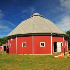
Maria and Franklin Wiltrout Polygonal Barn
14 km
Mountz House
279 m
John Wilderson House
1.5 km
William Fountain House
4.2 km
DeKalb County Home and Barn
5.6 km
Orin Clark House
3.6 km
Keyser Township School 8
1.4 km
Rakestraw House
3.8 km
Charles Lehmback Farmstead
1.5 km
Breechbill-Davidson House
2.8 kmVisited this place? Tap the stars to rate it and share your experience / photos with the community! Try now! You can cancel it anytime.
Discover hidden gems everywhere you go!
From secret cafés to breathtaking viewpoints, skip the crowded tourist spots and find places that match your style. Our app makes it easy with voice search, smart filtering, route optimization, and insider tips from travelers worldwide. Download now for the complete mobile experience.

A unique approach to discovering new places❞
— Le Figaro
All the places worth exploring❞
— France Info
A tailor-made excursion in just a few clicks❞
— 20 Minutes