Enable Location

We need your location to show you interesting places around you

Discover nearby places

Find interesting locations and hidden gems around you

Precise directions

Get accurate directions and distances to places

Your location is never shared with other users. It's only used when you tap the location button.

Duxbury Beach

Log in to your account

Start exploring — it's free

Trusted by 65,906 travelers worldwide

Continue with Google
Continue with Apple
or

We will send you a code to connect

By continuing, you accept our Terms and Conditions and our Privacy Policy

Check your inbox

We've sent a pincode in your inbox. Please enter the code below.

Discussion Reviews 1 Photos
5.5k Popularity

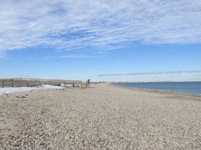
Duxbury Beach, 6-mile beach in Duxbury, Massachusetts, US.

Duxbury Beach is a long, sandy barrier beach on Cape Cod Bay in Massachusetts, running between the towns of Marshfield and Plymouth. The sand is wide and flat, and the beach has marked swimming zones, a snack bar, and restrooms near the main access points.

The area was set aside for public recreation in the early 1900s, and the barrier beach has kept its natural shape through careful management over the decades. Efforts to control erosion and protect the dune system have been ongoing since the mid-20th century.

The beach is a gathering spot for families from the surrounding towns, many of whom return every summer as part of a long-standing habit. Early mornings tend to draw walkers and fishermen, while afternoons bring swimmers and picnickers.

Summer is the busiest time, but the beach is open and walkable in spring and fall as well. Before swimming, it is worth checking the tide schedule, as the water level can shift quickly in some sections of the beach.

Duxbury Beach is one of the longest barrier beaches in New England, and behind it lies a large salt marsh that most visitors never see. That marsh supports nesting shorebirds that are legally protected, so parts of the beach close each year during breeding season.

The community of curious travelers

AroundUs brings together thousands of curated places, local tips, and hidden gems, enriched daily by 60,000 contributors worldwide.

Start exploring
GPS coordinates
42.04177,-70.63559
Latest update
March 3, 2026 10:08
Around this place
Mayflower II
United States of America

Mayflower II

9.4 km
Clark's Island
United States of America

Clark's Island

3.7 km
John and Priscilla Alden Family Sites
United States of America

John and Priscilla Alden Family Sites

4.2 km
Alexander Standish House
United States of America

Alexander Standish House

5.2 km
Plymouth Light
United States of America

Plymouth Light

5.1 km
Duxbury Pier Light
United States of America

Duxbury Pier Light

6.1 km
Holmes Reservation
United States of America

Holmes Reservation

8.8 km
King Caesar House
United States of America

King Caesar House

2.4 km
Isaac Winslow House
United States of America

Isaac Winslow House

4.5 km
Art Complex Museum
United States of America

Art Complex Museum

4.3 km
Thomas-Webster Estate
United States of America

Thomas-Webster Estate

5.5 km
Daniel Webster Law Office
United States of America

Daniel Webster Law Office

4.6 km
Bradford House
United States of America

Bradford House

9.5 km
Wright Memorial Library
United States of America

Wright Memorial Library

3.7 km
Nathaniel Winsor, Jr. House
United States of America

Nathaniel Winsor, Jr. House

3 km
Plymouth Antiquarian House
United States of America

Plymouth Antiquarian House

9.5 km
Pillsbury Summer House
United States of America

Pillsbury Summer House

3.1 km
Old Shipbuilder's Historic District
United States of America

Old Shipbuilder's Historic District

3.3 km
Captain Daniel Bradford House
United States of America

Captain Daniel Bradford House

4.1 km
Capt. Gamaliel Bradford House
United States of America

Capt. Gamaliel Bradford House

4.5 km
Frederic C. Adams Public Library
United States of America

Frederic C. Adams Public Library

9.3 km
Capt. Gershom Bradford House
United States of America

Capt. Gershom Bradford House

4.5 km
William Sever House
United States of America

William Sever House

9.2 km
Old Town Hall Historic District
United States of America

Old Town Hall Historic District

4.7 km
Tarkiln School
United States of America

Tarkiln School

8.7 km
Cove Street Historic District
United States of America

Cove Street Historic District

3.1 km
Myles Standish Burial Ground
United States of America

Myles Standish Burial Ground

4.7 km
Myles Standish Monument State Reservation
United States of America

Myles Standish Monument State Reservation

4.9 km
Show the full map
Reviews
Share your experience

No review yet

Discussions
Start a discussion...

No discussion yet

« Duxbury Beach - 6-mile beach in Duxbury, Massachusetts, US » is provided by Around Us (aroundus.com). Images and texts are derived from Wikimedia project under a Creative Commons license. You are allowed to copy, distribute, and modify copies of this page, under the conditions set by the license, as long as this note is clearly visible.

Discover hidden gems everywhere you go!

From secret cafés to breathtaking viewpoints, skip the crowded tourist spots and find places that match your style. Our app makes it easy with voice search, smart filtering, route optimization, and insider tips from travelers worldwide. Download now for the complete mobile experience.

Around Us App Screenshot

A unique approach to discovering new places

Le Figaro

All the places worth exploring

France Info

A tailor-made excursion in just a few clicks

20 Minutes

Around Us
Travel Guide & Maps
Download

Send to your phone

QR Code
1

Open the camera app on your mobile.

2

Point at the QR code with your camera. A notification will appear.

3

Tap the notification to open the link.