Mount Iriga, Stratovolcano in Camarines Sur, Philippines
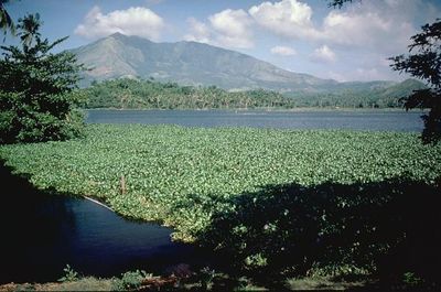
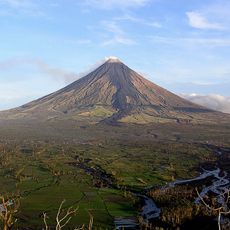
Mount Iriga is a stratovolcano in the Bicol region that rises 1,196 meters above sea level with a base diameter of about 10 kilometers. The cone sits near Lake Buhi and forms part of a larger volcanic chain in the area.
The volcano erupted twice during the seventeenth century, in 1628 and 1642, representing its last recorded activity. Since then the mountain has remained dormant without any further volcanic events.
Local communities know this volcano by an alternative name, Mount Asog, which appears in their traditional stories and folklore. The mountain remains woven into how residents understand and relate to their landscape today.
Multiple hiking paths of varying difficulty lead up the slope, with starting points accessible through local communities in the area. Visitors should prepare for mountain conditions and check trail accessibility before heading out.
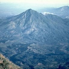
The volcano has a large crater formed by a debris avalanche event, creating a distinctive geological feature. This type of crater formation makes it geologically different from neighboring volcanoes.
Elevation above the sea: 1,143 m
GPS coordinates: 13.45581,123.45602
Latest update: December 7, 2025 20:45
Mayon Volcano
33.3 km
Mount Isarog
24.3 km
Minor Basilica and National Shrine of Our Lady of Peñafrancia
33.9 km
Mayon Volcano Natural Park
33.3 km
Mount Masaraga
22.5 km
Tabaco Church
31.4 km
Nabua Church
10.5 km
Buhi Church
7.1 km
Baao Church
9.7 km
Smith, Bell and Company House
31.7 km
Mount Isarog Natural Park
23 km
Panicuason Hot Springs Resort
28.1 km
Tabaco City Hall
31.6 km
Iglesia ni Cristo chapel, Nabua, Bicol
10.5 km
Jorge Barlin é Imperial historical marker
9.8 km
Angela Manalang Gloria historical marker
31.7 km
Simeon Arboleda Ola historical marker
33.5 km
Commercial Building of Smith, Bell & Co. Tabaco, Albay historical marker
31.7 km
Philtranco Transport Heritage Museum
5.4 km
Jorge Barlin Monument
9.8 km
Tabaco Presidencia Building historical marker
31.6 km
Iriga Church
6.2 km
Church of Nabua historical marker
10.5 km
Church of Milaor historical marker
34 km
Church of Baao historical marker
9.7 km
Church of Bula historical marker
19.4 km
Philtranco Service Enterprises, Inc. historical marker
5.4 km
Church of Buhi historical marker
7.1 kmReviews
Visited this place? Tap the stars to rate it and share your experience / photos with the community! Try now! You can cancel it anytime.
Discover hidden gems everywhere you go!
From secret cafés to breathtaking viewpoints, skip the crowded tourist spots and find places that match your style. Our app makes it easy with voice search, smart filtering, route optimization, and insider tips from travelers worldwide. Download now for the complete mobile experience.
A unique approach to discovering new places❞
— Le Figaro
All the places worth exploring❞
— France Info
A tailor-made excursion in just a few clicks❞
— 20 Minutes