Enable Location

We need your location to show you interesting places around you

Discover nearby places

Find interesting locations and hidden gems around you

Precise directions

Get accurate directions and distances to places

Your location is never shared with other users. It's only used when you tap the location button.

Mount Apo

Log in to your account

Start exploring — it's free

Trusted by 62,119 travelers worldwide

Continue with Google
Continue with Apple
or

We will send you a code to connect

By continuing, you accept our Terms and Conditions and our Privacy Policy

Check your inbox

We've sent a pincode in your inbox. Please enter the code below.

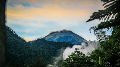
Mount Apo, Dormant stratovolcano in Davao Region, Philippines

This peak rises across several provinces in Mindanao and reaches nearly three thousand meters above sea level. Dense rainforest covers the lower slopes and gives way to moss forest and alpine grassland at higher elevations.

Spanish explorers first mentioned the volcano in written records during the seventeenth century. The government established protected areas around the peak in the twentieth century after logging threatened the forests.

The Bagobo people consider the summit a sacred space and home to ancestral spirits. Visitors may sometimes see local guides leave small offerings of betel leaves and rice before ascending.

Hikers should hire a guide from one of the surrounding towns since weather can shift quickly and trail markers are sparse in some sections. Physical preparation helps with the steep sections and the shifting temperatures between base and summit.

Sulfur vents bubble near the summit crater and warm the water naturally, inviting hikers to bathe after the climb. Wild orchids with species found only here grow in the mid-elevation zones along the trails.

The community of curious travelers

AroundUs brings together thousands of curated places, local tips, and hidden gems, enriched daily by 60,000 contributors worldwide.

Start exploring
Location
Location
Elevation above the sea
2,954 m
GPS coordinates
6.98734,125.27100
Latest update
December 14, 2025 20:43
Natural landmarks of the Philippines for photography

The Philippines display rice terraces in Ifugao mountains, coral reefs in Tubbataha National Park, and cave systems in Samar. Mayon Volcano shows its geometric shape, while Chocolate Hills of Bohol extend across the landscape. White sand beaches line the coasts of Boracay and Palawan.

« Mount Apo - Dormant stratovolcano in Davao Region, Philippines » is provided by Around Us (aroundus.com). Images and texts are derived from Wikimedia project under a Creative Commons license. You are allowed to copy, distribute, and modify copies of this page, under the conditions set by the license, as long as this note is clearly visible.

Discover hidden gems everywhere you go!

From secret cafés to breathtaking viewpoints, skip the crowded tourist spots and find places that match your style. Our app makes it easy with voice search, smart filtering, route optimization, and insider tips from travelers worldwide. Download now for the complete mobile experience.

Around Us App Screenshot

A unique approach to discovering new places

Le Figaro

All the places worth exploring

France Info

A tailor-made excursion in just a few clicks

20 Minutes

Around Us
Travel Guide & Maps
Download

Send to your phone

QR Code
1

Open the camera app on your mobile.

2

Point at the QR code with your camera. A notification will appear.

3

Tap the notification to open the link.