Khanakai, Höhle in Pakistan
Location: Federally Administered Tribal Areas
GPS coordinates: 34.20528,71.17611
Latest update: November 12, 2025 21:55
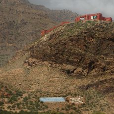
Ali Masjid Fort
20.5 km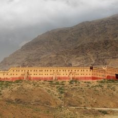
Shagai Fort
23 km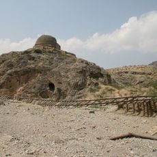
Sphola Stupa
14.8 km
Bazar Caves
7.6 km
Ware Gārē Sar
4.8 km
Ghutti Sar
16.1 km
Uchnao Sar
3.4 km
Amankowt Ghar
21.6 km
Tangai Ghar
23.3 km
Tsapara
27 km
Prantip Sar
8.8 km
Zīra Sar
27.4 km
Sherabad Ghar
15.1 km
Tang Nāo Sar
18.9 km
Shakri Sar
18.2 km
Zir Sar
20.2 km
Spīnkai
28.6 km
Gorāpari
8 km
Janat Gul Kili
24.3 km
Tor Ghund
9.8 km
Sarkhandai
26.1 km
Sur Kamar Caves
26 km
Zerai Garai (langub)
27.6 km
Shakar Tangi (langub sa Pakistan)
28.3 km
Paso Jáiber
12 km
Shagai Fort
23 km
Buddhist Stupa
14.8 km
Pakistan Chowk DHA Peshawar
28.8 kmReviews
Visited this place? Tap the stars to rate it and share your experience / photos with the community! Try now! You can cancel it anytime.
Discover hidden gems everywhere you go!
From secret cafés to breathtaking viewpoints, skip the crowded tourist spots and find places that match your style. Our app makes it easy with voice search, smart filtering, route optimization, and insider tips from travelers worldwide. Download now for the complete mobile experience.

A unique approach to discovering new places❞
— Le Figaro
All the places worth exploring❞
— France Info
A tailor-made excursion in just a few clicks❞
— 20 Minutes