Koutammakou

Log in to your account

AroundUs is a community-driven map of interesting places, built by curious explorers like you. It grows with every review, story, and photo you share.
Connect to save your favorite spots, contribute locations, and create personalized routes.
By continuing, you accept our Terms and Conditions and our Privacy Policy
Add to collection
Map
Suggest a change
Share

Koutammakou, Nature reserve in northeastern Togo.
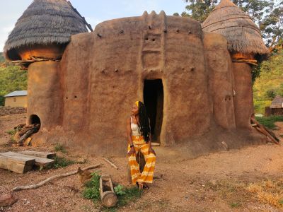
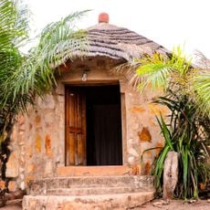
The Koutammakou landscape spans 500 square kilometers of land featuring traditional mud tower houses called Takienta spread across rolling hills and fertile valleys.

The area gained UNESCO World Heritage status in 2004, recognizing the enduring settlement patterns and architectural traditions of the Batammariba people in northeastern Togo.

The Batammariba people construct their multi-story mud houses with specific areas for living quarters, livestock spaces, and granaries, following ancient building techniques.

Visitors need to arrange local guides in advance and plan for a 2.5-hour drive from Kara via Kandé to reach the nature reserve.

Each Takienta house contains dedicated shrines with conical structures at the entrance, protecting the inhabitants according to local spiritual beliefs.

Location: Kéran

Address: Dissani, Togo Dissani Dissani

GPS coordinates: 10.10839,1.14027

Latest update: March 7, 2025 02:12

Visit of Noteworthy Sites and Cultural Locations in Togo

Togo extends from the coast of the Gulf of Guinea to forested plateaus inland. The country contains several national parks, including Fazao Malfakassa and Keran, where elephants, antelopes, and numerous bird species live. The waterfalls at Aklowa and Kpimé cascade over multiple tiers through tropical vegetation. The Koutammakou region in the northeast displays traditional clay architecture with characteristic Tatas, fortified dwellings of the Batammariba people. In Lomé, German and French colonial buildings reflect the history of the 19th and 20th centuries, while local markets like the Marché des Féticheurs present traditional practices and commerce. Mount Agou rises to 986 meters and provides views across surrounding valleys and plantations. The coastal area includes sandy beaches along the Atlantic and Lac Togo, a lagoon used for fishing and water activities. Temple ruins and shrines are distributed throughout the country, documenting the animist traditions of various ethnic groups.

Reviews

Visited this place? Tap the stars to rate it and share your experience / photos with the community! Try now! You can cancel it anytime.

« Koutammakou: Nature reserve in northeastern Togo » is provided by Around Us (aroundus.com). Images and texts are derived from Wikimedia project under a Creative Commons license. You are allowed to copy, distribute, and modify copies of this page, under the conditions set by the license, as long as this note is clearly visible.

Discover hidden gems everywhere you go!

From secret cafés to breathtaking viewpoints, skip the crowded tourist spots and find places that match your style. Our app makes it easy with voice search, smart filtering, route optimization, and insider tips from travelers worldwide. Download now for the complete mobile experience.

Around Us App Screenshot

A unique approach to discovering new places

Le Figaro

All the places worth exploring

France Info

A tailor-made excursion in just a few clicks

20 Minutes