Cerro Gordo County

Log in to your account

AroundUs is a community-driven map of interesting places, built by curious explorers like you. It grows with every review, story, and photo you share.
Connect to save your favorite spots, contribute locations, and create personalized routes.
Continue with Google
Continue with Apple
Continue with X
Continue with Facebook
Continue with email
By continuing, you accept our Terms and Conditions and our Privacy Policy
Create an account
Add to collection
Map
Suggest a change
Share

Cerro Gordo County, Administrative county in north-central Iowa, US.

Cerro Gordo County is an administrative county in north-central Iowa centered on Mason City as its seat, with Clear Lake as another significant population hub. The county encompasses several municipalities and towns connected by state and federal highways through rolling terrain.

The county was established in 1851, taking its name from the Battle of Cerro Gordo during the Mexican-American War where General Winfield Scott defeated Mexican forces. This naming reflects how early settlers drew on major national events when establishing local jurisdictions.

The county gained national attention when a plane crash near Grant Township claimed the lives of musicians Buddy Holly, Ritchie Valens, and J.P. Richardson in 1959.

Highway 35 runs north-south through the county while Highways 18 and 65 provide key east-west connections for getting around. Mason City Municipal Airport handles regional air travel for visitors arriving or departing by plane.

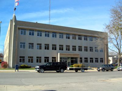
The county government operates through a three-member Board of Supervisors system, managing sixteen distinct townships across its jurisdiction.

Location: Iowa

Inception: 1851

Capital city: Mason City

Shares border with: Worth County, Franklin County, Winnebago County, Hancock County, Wright County, Mitchell County, Floyd County, Butler County

Website: http://co.cerro-gordo.ia.us

GPS coordinates: 43.07944,-93.26694

Latest update: December 7, 2025 19:24

Photos
Around this place
Surf Ballroom
United States of America

Surf Ballroom

12 km
Dr. G.C. Stockman House
United States of America

Dr. G.C. Stockman House

10.2 km
First National Bank of Mason City
United States of America

First National Bank of Mason City

9.7 km
MBA Building
United States of America

MBA Building

9.8 km
Len Jus Building
United States of America

Len Jus Building

9.9 km
Prof. J.L. Budd, Sarah M., and Etta Budd House
United States of America

Prof. J.L. Budd, Sarah M., and Etta Budd House

10.8 km
Rock Crest–Rock Glen Historic District
United States of America

Rock Crest–Rock Glen Historic District

10 km
Mason City Public Library
United States of America

Mason City Public Library

9.9 km
Cerro Gordo County Courthouse
United States of America

Cerro Gordo County Courthouse

9.8 km
The Kirk
United States of America

The Kirk

9.8 km
Parker's Opera House
United States of America

Parker's Opera House

9.8 km
Duncan Rule House
United States of America

Duncan Rule House

9.8 km
East Park
United States of America

East Park

10.7 km
East Park Band Shell
United States of America

East Park Band Shell

10.7 km
Mason City Downtown Historic District
United States of America

Mason City Downtown Historic District

9.8 km
St. John Baptist Church
United States of America

St. John Baptist Church

7.4 km
First Church of Christ, Scientist
United States of America

First Church of Christ, Scientist

9.8 km
Stewart Avenue Bridge
United States of America

Stewart Avenue Bridge

10.6 km
Mason City YMCA
United States of America

Mason City YMCA

9.9 km
Winnebago River Bridge
United States of America

Winnebago River Bridge

13.5 km
George Romey House
United States of America

George Romey House

10 km
William C. and Margaret Egloff House
United States of America

William C. and Margaret Egloff House

9.9 km
A.J. Andrus Duplex
United States of America

A.J. Andrus Duplex

10.3 km
Hotel Lester-Lester Cafe
United States of America

Hotel Lester-Lester Cafe

9.6 km
Parker's Woods
United States of America

Parker's Woods

9.4 km
Curtis Yelland House
United States of America

Curtis Yelland House

9.7 km
Rogers-Knutson House
United States of America

Rogers-Knutson House

11.7 km
Mier Wolf House
United States of America

Mier Wolf House

10.3 km
Show the full map
Reviews

Visited this place? Tap the stars to rate it and share your experience / photos with the community! Try now! You can cancel it anytime.

Administrative divisions
« Cerro Gordo County - Administrative county in north-central Iowa, US » is provided by Around Us (aroundus.com). Images and texts are derived from Wikimedia project under a Creative Commons license. You are allowed to copy, distribute, and modify copies of this page, under the conditions set by the license, as long as this note is clearly visible.

Discover hidden gems everywhere you go!

From secret cafés to breathtaking viewpoints, skip the crowded tourist spots and find places that match your style. Our app makes it easy with voice search, smart filtering, route optimization, and insider tips from travelers worldwide. Download now for the complete mobile experience.

Around Us App Screenshot

A unique approach to discovering new places

Le Figaro

All the places worth exploring

France Info

A tailor-made excursion in just a few clicks

20 Minutes