Ionia County

Log in to your account

AroundUs is a community-driven map of interesting places, built by curious explorers like you. It grows with every review, story, and photo you share.
Connect to save your favorite spots, contribute locations, and create personalized routes.
Continue with Google
Continue with Apple
Continue with X
Continue with Facebook
Continue with email
By continuing, you accept our Terms and Conditions and our Privacy Policy
Create an account
Add to collection
Map
Suggest a change
Share

Ionia County, County administration center in Michigan, United States

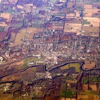
Ionia County is an administrative division in central Michigan spanning roughly 580 square miles. It contains multiple cities, villages, and townships that form part of the larger Grand Rapids-Kentwood metropolitan region.

The county officially came into existence on March 2, 1831, named after the ancient Greek region of Ionia. Its establishment reflected the westward expansion and settlement patterns in this part of Michigan during the early 1800s.

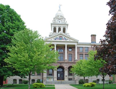
The courthouse serves as the heart of county government and a gathering place for residents handling official matters. The building's presence shapes how people understand local authority and community services.

Multiple highways including I-96, M-21, and M-66 run through the county, making travel between communities straightforward. These routes connect to neighboring regions and make it easy to navigate across the various towns and townships.

The name Ionia references an ancient cultural region on the eastern Mediterranean, reflecting classical roots embedded in this American administrative area. This naming choice was a common practice in the 1800s when settlers honored Old World geography.

Location: Michigan

Inception: March 2, 1831

Capital city: Ionia

Shares border with: Montcalm County, Barry County, Eaton County, Clinton County, Gratiot County, Kent County

Website: http://ioniacounty.org

GPS coordinates: 42.94000,-85.07000

Latest update: December 7, 2025 20:21

Photos
Around this place
Whites Bridge
United States of America

Whites Bridge

20.4 km
Ionia State Recreation Area
United States of America

Ionia State Recreation Area

5.3 km
John C. Blanchard House
United States of America

John C. Blanchard House

4.9 km
Sessions Schoolhouse
United States of America

Sessions Schoolhouse

5.4 km
Richardson Silk Mill
United States of America

Richardson Silk Mill

22.1 km
Hall-Fowler Memorial Library
United States of America

Hall-Fowler Memorial Library

4.9 km
Portland School Apartments
United States of America

Portland School Apartments

15.8 km
Portland First Congregational Church
United States of America

Portland First Congregational Church

19.6 km
Ionia Downtown Commercial Historic District
United States of America

Ionia Downtown Commercial Historic District

4.7 km
William H. VanderHeyden House
United States of America

William H. VanderHeyden House

4.6 km
Alvah N. Belding Memorial Library
United States of America

Alvah N. Belding Memorial Library

21.7 km
Ionia County Courthouse
United States of America

Ionia County Courthouse

4.9 km
Lovell-Webber House
United States of America

Lovell-Webber House

4.9 km
Portland Downtown Historic District
United States of America

Portland Downtown Historic District

15.7 km
Ionia Historic District
United States of America

Ionia Historic District

4.9 km
Muir Church of Christ
United States of America

Muir Church of Christ

12.4 km
Ionia Theatre
United States of America

Ionia Theatre

4.8 km
St. John the Baptist Catholic Church Complex
United States of America

St. John the Baptist Catholic Church Complex

24.8 km
Fred W Green Historical Marker
United States of America

Fred W Green Historical Marker

5 km
Ionia County Courthouse Historical Marker
United States of America

Ionia County Courthouse Historical Marker

4.9 km
Saranac Public Library
United States of America

Saranac Public Library

11.7 km
Saint John's Episcopal Church and Parish House Historical Marker
United States of America

Saint John's Episcopal Church and Parish House Historical Marker

4.9 km
Saranac Historical Marker
United States of America

Saranac Historical Marker

10.9 km
Ionia Community Library
United States of America

Ionia Community Library

4.8 km
John C Blanchard Historical Marker
United States of America

John C Blanchard Historical Marker

5 km
Frederick Hall House Historical Marker
United States of America

Frederick Hall House Historical Marker

4.8 km
Ionia Church of Christ Historical Marker
United States of America

Ionia Church of Christ Historical Marker

4.9 km
Church of Christ Historical Marker
United States of America

Church of Christ Historical Marker

12.4 km
Show the full map
Reviews

Visited this place? Tap the stars to rate it and share your experience / photos with the community! Try now! You can cancel it anytime.

Administrative divisions
« Ionia County - County administration center in Michigan, United States » is provided by Around Us (aroundus.com). Images and texts are derived from Wikimedia project under a Creative Commons license. You are allowed to copy, distribute, and modify copies of this page, under the conditions set by the license, as long as this note is clearly visible.

Discover hidden gems everywhere you go!

From secret cafés to breathtaking viewpoints, skip the crowded tourist spots and find places that match your style. Our app makes it easy with voice search, smart filtering, route optimization, and insider tips from travelers worldwide. Download now for the complete mobile experience.

Around Us App Screenshot

A unique approach to discovering new places

Le Figaro

All the places worth exploring

France Info

A tailor-made excursion in just a few clicks

20 Minutes