Enable Location

We need your location to show you interesting places around you

Discover nearby places

Find interesting locations and hidden gems around you

Precise directions

Get accurate directions and distances to places

Your location is never shared with other users. It's only used when you tap the location button.

Whites Bridge

Log in to your account

Start exploring — it's free

Trusted by 62,387 travelers worldwide

Continue with Google
Continue with Apple
or

We will send you a code to connect

By continuing, you accept our Terms and Conditions and our Privacy Policy

Check your inbox

We've sent a pincode in your inbox. Please enter the code below.

Whites Bridge

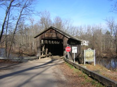
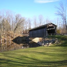
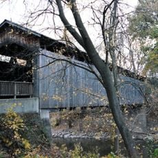
Whites Bridge, Covered bridge in Keene Township, Michigan.

Whites Bridge is a covered bridge with Brown truss design that spans the Flat River with wooden construction and a gabled roof. The structure connects communities across the waterway in Ionia County, Michigan.

The original bridge was built in 1869 by Jared N. Brazee and J.N. Walker. After a fire destroyed it in 2013, it was reconstructed in 2020.

The bridge reflects 19th century American construction methods through its wooden pegs and hand-forged nails. Walking through it, you can see the craftsmanship that builders applied to everyday infrastructure.

You can reach the bridge via Whites Bridge Road north of Belding in Ionia County. Plan for rural road conditions and allow time to walk through the structure and take photos.

The construction used second-hand lumber to cut costs and was completed in just 84 days. This rapid building pace was remarkable for a structure of its size using reclaimed materials.

The community of curious travelers

AroundUs brings together thousands of curated places, local tips, and hidden gems, enriched daily by 60,000 contributors worldwide.

Start exploring
Location
Official opening
1869
GPS coordinates
43.01510,-85.29910
Latest update
December 11, 2025 11:01
Around this place
North Country Trail
United States of America

North Country Trail

9.5 km
Fallasburg Bridge
United States of America

Fallasburg Bridge

4.4 km
Ada Covered Bridge
United States of America

Ada Covered Bridge

16.8 km
Ionia State Recreation Area
United States of America

Ionia State Recreation Area

15.5 km
Greenville Downtown Historic District
United States of America

Greenville Downtown Historic District

18.7 km
Sessions Schoolhouse
United States of America

Sessions Schoolhouse

15.1 km
Richardson Silk Mill
United States of America

Richardson Silk Mill

10.7 km
Ionia Downtown Commercial Historic District
United States of America

Ionia Downtown Commercial Historic District

19.2 km
William H. VanderHeyden House
United States of America

William H. VanderHeyden House

18.3 km
Fallasburg Historic District
United States of America

Fallasburg Historic District

4.2 km
Alvah N. Belding Memorial Library
United States of America

Alvah N. Belding Memorial Library

11 km
Ionia County Courthouse
United States of America

Ionia County Courthouse

19.5 km
Thornapple River Drive Bridge
United States of America

Thornapple River Drive Bridge

17.8 km
Graham House
United States of America

Graham House

9.7 km
Lovell-Webber House
United States of America

Lovell-Webber House

19.4 km
Ionia Theatre
United States of America

Ionia Theatre

19.4 km
Ionia County Courthouse Historical Marker
United States of America

Ionia County Courthouse Historical Marker

19.6 km
Fred W Green Historical Marker
United States of America

Fred W Green Historical Marker

19.5 km
Ada-Lowell 5 Theatres
United States of America

Ada-Lowell 5 Theatres

10.6 km
Saranac Public Library
United States of America

Saranac Public Library

11.7 km
Saint John's Episcopal Church and Parish House Historical Marker
United States of America

Saint John's Episcopal Church and Parish House Historical Marker

19.5 km
Ionia Church of Christ Historical Marker
United States of America

Ionia Church of Christ Historical Marker

19.5 km
Robert W Graham Home Historical Marker
United States of America

Robert W Graham Home Historical Marker

9.7 km
Lowell Showboat
United States of America

Lowell Showboat

9.5 km
Saranac Historical Marker
United States of America

Saranac Historical Marker

12.2 km
Strand Theatre
United States of America

Strand Theatre

9.7 km
Brower Lake Nature Preserve
United States of America

Brower Lake Nature Preserve

18.9 km
Bog at Browers Lake Nature Preserve
United States of America

Bog at Browers Lake Nature Preserve

19.5 km
Show the full map
« Whites Bridge - Covered bridge in Keene Township, Michigan » is provided by Around Us (aroundus.com). Images and texts are derived from Wikimedia project under a Creative Commons license. You are allowed to copy, distribute, and modify copies of this page, under the conditions set by the license, as long as this note is clearly visible.

Discover hidden gems everywhere you go!

From secret cafés to breathtaking viewpoints, skip the crowded tourist spots and find places that match your style. Our app makes it easy with voice search, smart filtering, route optimization, and insider tips from travelers worldwide. Download now for the complete mobile experience.

Around Us App Screenshot

A unique approach to discovering new places

Le Figaro

All the places worth exploring

France Info

A tailor-made excursion in just a few clicks

20 Minutes

Around Us
Travel Guide & Maps
Download

Send to your phone

QR Code
1

Open the camera app on your mobile.

2

Point at the QR code with your camera. A notification will appear.

3

Tap the notification to open the link.