Fallasburg Bridge

Log in to your account

AroundUs is a community-driven map of interesting places, built by curious explorers like you. It grows with every review, story, and photo you share.
Connect to save your favorite spots, contribute locations, and create personalized routes.
Continue with Google
Continue with Apple
Continue with X
Continue with Facebook
Continue with email
By continuing, you accept our Terms and Conditions and our Privacy Policy
Create an account
Add to collection
Map
Suggest a change
Share

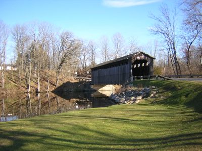
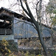
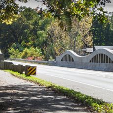
Fallasburg Bridge, Brown truss covered bridge in Vergennes Township, Michigan, US

Fallasburg Bridge is a wooden covered bridge crossing the Flat River using the Brown truss design, a method that combines diagonal compression beams with vertical tension members for support. The structure stands on concrete and fieldstone footings, allowing it to span the water while maintaining its original architectural system from the 19th century.

Built in 1871, the bridge was designed using the Brown truss system, an engineering method that was already proven by that time. The structure was adapted in 1905 when modern concrete and stone footings replaced the original foundation to extend its usefulness.

The bridge serves as a landmark in the Fallasburg Historical District, representing the kind of engineering that shaped rural communities in Michigan. It shows how practical construction solutions became sources of local pride over time.

The bridge is located about 5 miles north of Lowell and is accessible by regular roads leading through Vergennes Township. Vehicles are restricted to under 3 tons, so it is best to approach slowly and share the crossing with pedestrians and cyclists.

This is one of only four remaining covered bridges in Michigan that still permits vehicle traffic, making it an active part of the transportation network rather than just a museum piece. Most other structures of this type in the state have been closed to vehicles or moved elsewhere, which makes this one especially valuable.

Location: Vergennes Township

Inception: 1871

Official opening: 1871

GPS coordinates: 42.98083,-85.32722

Latest update: December 12, 2025 09:01

Photos
Around this place
North Country Trail
United States of America

North Country Trail

5.2 km
Frederik Meijer Gardens & Sculpture Park
United States of America

Frederik Meijer Gardens & Sculpture Park

21 km
Whites Bridge
United States of America

Whites Bridge

4.4 km
Ada Covered Bridge
United States of America

Ada Covered Bridge

13.3 km
Ionia State Recreation Area
United States of America

Ionia State Recreation Area

16.2 km
Sessions Schoolhouse
United States of America

Sessions Schoolhouse

16.1 km
Richardson Silk Mill
United States of America

Richardson Silk Mill

15.2 km
Ionia Downtown Commercial Historic District
United States of America

Ionia Downtown Commercial Historic District

21.2 km
William H. VanderHeyden House
United States of America

William H. VanderHeyden House

20.2 km
Fallasburg Historic District
United States of America

Fallasburg Historic District

352 m
Alvah N. Belding Memorial Library
United States of America

Alvah N. Belding Memorial Library

15.4 km
Thornapple River Drive Bridge
United States of America

Thornapple River Drive Bridge

14.1 km
Graham House
United States of America

Graham House

5.4 km
Lovell-Webber House
United States of America

Lovell-Webber House

21.4 km
Ionia Theatre
United States of America

Ionia Theatre

21.3 km
Ada-Lowell 5 Theatres
United States of America

Ada-Lowell 5 Theatres

6.2 km
Saranac Public Library
United States of America

Saranac Public Library

10.8 km
Ionia Church of Christ Historical Marker
United States of America

Ionia Church of Christ Historical Marker

21.4 km
Robert W Graham Home Historical Marker
United States of America

Robert W Graham Home Historical Marker

5.3 km
Saranac Historical Marker
United States of America

Saranac Historical Marker

11.5 km
Strand Theatre
United States of America

Strand Theatre

5.3 km
Lowell Showboat
United States of America

Lowell Showboat

5.2 km
Cascade Township Branch
United States of America

Cascade Township Branch

16.4 km
Brower Lake Nature Preserve
United States of America

Brower Lake Nature Preserve

20.1 km
CSX Thornapple River Bridge
United States of America

CSX Thornapple River Bridge

16.7 km
Cascade Township Hall Historical Marker
United States of America

Cascade Township Hall Historical Marker

15.8 km
Cascade Christian Church Historical Marker
United States of America

Cascade Christian Church Historical Marker

15.9 km
Bog at Browers Lake Nature Preserve
United States of America

Bog at Browers Lake Nature Preserve

20.8 km
Show the full map
Reviews

Visited this place? Tap the stars to rate it and share your experience / photos with the community! Try now! You can cancel it anytime.

« Fallasburg Bridge - Brown truss covered bridge in Vergennes Township, Michigan, US » is provided by Around Us (aroundus.com). Images and texts are derived from Wikimedia project under a Creative Commons license. You are allowed to copy, distribute, and modify copies of this page, under the conditions set by the license, as long as this note is clearly visible.

Discover hidden gems everywhere you go!

From secret cafés to breathtaking viewpoints, skip the crowded tourist spots and find places that match your style. Our app makes it easy with voice search, smart filtering, route optimization, and insider tips from travelers worldwide. Download now for the complete mobile experience.

Around Us App Screenshot

A unique approach to discovering new places

Le Figaro

All the places worth exploring

France Info

A tailor-made excursion in just a few clicks

20 Minutes