Deaf Smith County

Log in to your account

AroundUs is a community-driven map of interesting places, built by curious explorers like you. It grows with every review, story, and photo you share.
Connect to save your favorite spots, contribute locations, and create personalized routes.
By continuing, you accept our Terms and Conditions and our Privacy Policy
Add to collection
Map
Suggest a change
Share

Deaf Smith County, County in Texas Panhandle, United States

Deaf Smith County is an administrative division in the Texas Panhandle near the New Mexico border. The landscape consists of flat plains and gently rolling terrain at the western edge of the Llano Estacado plateau.

The Texas Legislature established this county in 1876 from the Bexar District and named it after Erastus Smith, a scout during the Texas Revolution. The naming honored a key figure in the state's early independence movement.

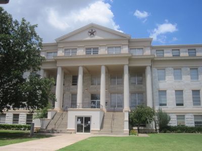
The Deaf Smith County Historical Museum in Hereford shows how ranching and farming shaped daily life through displayed objects and old photographs. The place tells the story of transportation routes that connected this area to the wider region.

The county clerk's office in Hereford handles elections, land records, and issues various official documents during business hours. Most administrative matters can be managed during weekday office hours.

Three creeks flow through the territory: Tierra Blanca Creek in the south and Palo Duro Creek and North Palo Duro Creek in the northeast. These waterways cut through the otherwise dry plateau and serve as key geographic features.

Location: Texas

Inception: 1890

Capital city: Hereford

Shares border with: Oldham County, Randall County, Castro County, Parmer County, Curry County, Quay County, Potter County

Website: http://co.deaf-smith.tx.us

GPS coordinates: 34.97000,-102.60000

Latest update: December 7, 2025 10:04

Photos
Around this place
Show the full map
Cadillac Ranch
United States of America

Cadillac Ranch

60.8 km
National Helium Reserve
United States of America

National Helium Reserve

63.7 km
American Quarter Horse Hall of Fame
United States of America

American Quarter Horse Hall of Fame

76.3 km
Don Harrington Discovery Center
United States of America

Don Harrington Discovery Center

67.6 km
Amarillo Civic Center
United States of America

Amarillo Civic Center

74.8 km
Atchison, Topeka and Santa Fe Railway 5000
United States of America

Atchison, Topeka and Santa Fe Railway 5000

75.1 km
Wonderland Park
United States of America

Wonderland Park

76.2 km
Buffalo Lake National Wildlife Refuge
United States of America

Buffalo Lake National Wildlife Refuge

44.8 km
Chase Tower
United States of America

Chase Tower

74.2 km
Santa Fe Building
United States of America

Santa Fe Building

74.1 km
Panhandle–Plains Historical Museum
United States of America

Panhandle–Plains Historical Museum

62.3 km
Amarillo National Bank Sox Stadium
United States of America

Amarillo National Bank Sox Stadium

77.5 km
Texas Tornado
United States of America

Texas Tornado

76.3 km
Amarillo Museum of Art
United States of America

Amarillo Museum of Art

73 km
Potter County Courthouse
United States of America

Potter County Courthouse

74.5 km
Sacred Heart Cathedral
United States of America

Sacred Heart Cathedral

74.3 km
First Methodist Church of Clovis
United States of America

First Methodist Church of Clovis

79.8 km
J. Marvin Jones Federal Building and United States Courthouse
United States of America

J. Marvin Jones Federal Building and United States Courthouse

74.6 km
1908 Clovis City Hall and Fire Station
United States of America

1908 Clovis City Hall and Fire Station

83.9 km
Curry County Courthouse
United States of America

Curry County Courthouse

83.8 km
Courtyard by Marriott, Downtown Amarillo
United States of America

Courtyard by Marriott, Downtown Amarillo

74.2 km
Deaf Smith County Historical Museum
United States of America

Deaf Smith County Historical Museum

24.9 km
Llano Cemetery
United States of America

Llano Cemetery

74.3 km
Carlile Theater
United States of America

Carlile Theater

53.6 km
Lighthouse Peak
United States of America

Lighthouse Peak

82.5 km
Randall County Courthouse
United States of America

Randall County Courthouse

61.3 km
Amarillo Natatorium
United States of America

Amarillo Natatorium

72 km
Amarillo Globe Dream House
United States of America

Amarillo Globe Dream House

72.8 km
Show the full map
Reviews

Visited this place? Tap the stars to rate it and share your experience / photos with the community! Try now! You can cancel it anytime.

Administrative divisions
« Deaf Smith County - County in Texas Panhandle, United States » is provided by Around Us (aroundus.com). Images and texts are derived from Wikimedia project under a Creative Commons license. You are allowed to copy, distribute, and modify copies of this page, under the conditions set by the license, as long as this note is clearly visible.

Discover hidden gems everywhere you go!

From secret cafés to breathtaking viewpoints, skip the crowded tourist spots and find places that match your style. Our app makes it easy with voice search, smart filtering, route optimization, and insider tips from travelers worldwide. Download now for the complete mobile experience.

Around Us App Screenshot

A unique approach to discovering new places

Le Figaro

All the places worth exploring

France Info

A tailor-made excursion in just a few clicks

20 Minutes