Mount Monadnock, National Natural Landmark mountain in Cheshire County, New Hampshire.
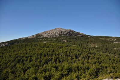
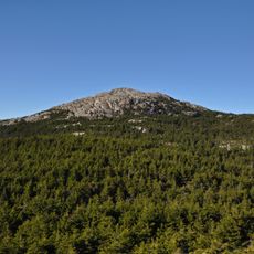
Mount Monadnock is a summit in Cheshire County in southwestern New Hampshire, rising roughly 965 meters (3,165 feet) above the surrounding plain. Its upper slopes expose crystalline schist with no tree cover, while several marked trails lead from the wooded base up to the rocky top.
Farmers set fires between 1800 and 1820 to create grazing land, permanently destroying the forest cover at higher elevations. These fires changed the appearance and left the summit bare and open, as seen today.
The mountain lies near Peterborough and Dublin, two small towns that serve as starting points for hikers. Its bare schist summit draws walkers from across New England who come to see views reaching into Vermont and Massachusetts on clear days.
The White Dot Trail offers the shortest route upward and takes roughly two to three hours depending on pace. Other routes spread across the flanks and offer quieter ascents for those wanting to avoid the main path.
The word monadnock comes from the Abenaki language and originally referred to this single hill standing above the flat surroundings. Geologists later adopted the term as a technical name for isolated rises formed by erosion of surrounding rock.
The community of curious travelers
AroundUs brings together thousands of curated places, local tips, and hidden gems, enriched daily by 60,000 contributors worldwide.