Enable Location

We need your location to show you interesting places around you

Discover nearby places

Find interesting locations and hidden gems around you

Precise directions

Get accurate directions and distances to places

Your location is never shared with other users. It's only used when you tap the location button.

Randolph County

Log in to your account

Start exploring — it's free

Trusted by 61,980 travelers worldwide

Continue with Google
Continue with Apple
or

We will send you a code to connect

By continuing, you accept our Terms and Conditions and our Privacy Policy

Check your inbox

We've sent a pincode in your inbox. Please enter the code below.

Randolph County, County seat in northern Missouri, United States

Randolph County is an administrative division in northern Missouri with rolling terrain and scattered communities. The area consists primarily of farmland interspersed with small towns and rural settlements.

The county was founded on January 22, 1829, and named after John Randolph, a Virginia statesman. Its establishment marked the region's incorporation into Missouri's administrative structure during westward expansion.

The county forms part of Little Dixie region, reflecting settlement patterns from Kentucky and Tennessee through agricultural practices and social traditions.

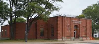
The courthouse in Huntsville serves as the main administrative center where visitors can access county services and records. The town provides basic amenities and serves as the central hub for county business.

General Omar Bradley, who rose to five-star military rank, originated from this county. His journey from rural Missouri to commanding general represents a remarkable local achievement.

The community of curious travelers

AroundUs brings together thousands of curated places, local tips, and hidden gems, enriched daily by 60,000 contributors worldwide.

Start exploring
Location
Inception
January 22, 1829
Capital city
Huntsville
Shares border with
Macon County, Boone County, Howard County, Monroe County, Audrain County, Chariton County
GPS coordinates
39.43000,-92.50000
Latest update
December 7, 2025 20:26
Around this place
Finger Lakes State Park
United States of America

Finger Lakes State Park

41 km
Union Covered Bridge State Historic Site
United States of America

Union Covered Bridge State Historic Site

34.2 km
Albert Bishop Chance House and Gardens
United States of America

Albert Bishop Chance House and Gardens

39.9 km
Wardell House
United States of America

Wardell House

34.8 km
Chatol
United States of America

Chatol

40.2 km
Glasgow Railroad Bridge
United States of America

Glasgow Railroad Bridge

38 km
United States of America

Morrison Observatory

35.3 km
Principia Astronomical Observatory
United States of America

Principia Astronomical Observatory

35.3 km
Glasgow Bridge, Missouri
United States of America

Glasgow Bridge, Missouri

38 km
Moberly Junior High School
United States of America

Moberly Junior High School

5 km
Glasgow Presbyterian Church
United States of America

Glasgow Presbyterian Church

37.2 km
Campbell Chapel African Methodist Episcopal Church
United States of America

Campbell Chapel African Methodist Episcopal Church

37.1 km
St. Mary's Episcopal Church
United States of America

St. Mary's Episcopal Church

35.4 km
Burkholder-O'Keefe House
United States of America

Burkholder-O'Keefe House

5.3 km
Oakwood
United States of America

Oakwood

34.9 km
Macon County Courthouse and Annex
United States of America

Macon County Courthouse and Annex

34.8 km
First Presbyterian Church
United States of America

First Presbyterian Church

37.6 km
Harrisburg School
United States of America

Harrisburg School

32.3 km
Moberly Commercial Historic District
United States of America

Moberly Commercial Historic District

5.4 km
Glasgow Public Library
United States of America

Glasgow Public Library

37.3 km
Salisbury Square Historic District
United States of America

Salisbury Square Historic District

25.9 km
Edwin and Nora Payne Bedford House
United States of America

Edwin and Nora Payne Bedford House

40.8 km
Dr. Uriel S. Wright Office
United States of America

Dr. Uriel S. Wright Office

35.3 km
Fayette Courthouse Square Historic District
United States of America

Fayette Courthouse Square Historic District

35.3 km
Redding-Hill House
United States of America

Redding-Hill House

37.6 km
Fabrishous and Sarah A. Thomas House
United States of America

Fabrishous and Sarah A. Thomas House

25.6 km
Long Branch State Park
United States of America

Long Branch State Park

38.1 km
4th Street Theatre
United States of America

4th Street Theatre

5.2 km
Show the full map
Administrative divisions
« Randolph County - County seat in northern Missouri, United States » is provided by Around Us (aroundus.com). Images and texts are derived from Wikimedia project under a Creative Commons license. You are allowed to copy, distribute, and modify copies of this page, under the conditions set by the license, as long as this note is clearly visible.

Discover hidden gems everywhere you go!

From secret cafés to breathtaking viewpoints, skip the crowded tourist spots and find places that match your style. Our app makes it easy with voice search, smart filtering, route optimization, and insider tips from travelers worldwide. Download now for the complete mobile experience.

Around Us App Screenshot

A unique approach to discovering new places

Le Figaro

All the places worth exploring

France Info

A tailor-made excursion in just a few clicks

20 Minutes

Around Us
Travel Guide & Maps
Download

Send to your phone

QR Code
1

Open the camera app on your mobile.

2

Point at the QR code with your camera. A notification will appear.

3

Tap the notification to open the link.