Chest opened
+${chestReward.xp} XP
Explorer
NOUVEAU ×${chestReward.collectible.quantity}
tapez pour fermer
Chest locked

Open chests in the app

Around Us is built for your phone — chests unlock when you walk, explore and capture nearby places.

Enable Location

We need your location to show you interesting places around you

Discover nearby places

Find interesting locations and hidden gems around you

Precise directions

Get accurate directions and distances to places

Your location is never shared with other users. It's only used when you tap the location button.

Dumfries

Log in to your account

Start exploring — it's free

Trusted by 72,889 travelers worldwide

Continue with Google
Continue with Apple
or

We will send you a code to connect

By continuing, you accept our Terms and Conditions and our Privacy Policy

Check your inbox

We've sent a pincode in your inbox. Please enter the code below.

Discussion Reviews 1 Photos
27.6k Popularity

Dumfries, Administrative division in Prince William County, Virginia, United States.

Dumfries is a town in Prince William County, Virginia, that sits along Quantico Creek south of Washington D.C. The area is marked by major transportation routes and several military facilities.

The town received its charter in 1749, making it Virginia's oldest continuously chartered municipality. It served as a major port for tobacco trade during colonial times.

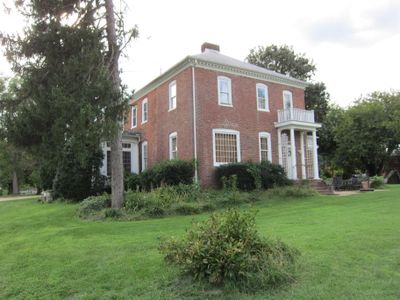
The Weems-Botts Museum occupies an 18th-century house and displays objects from the town's past through exhibits and guided tours. Visitors can see how daily life looked in colonial times and understand what mattered to people then.

Town Hall provides municipal services to residents during the week. It is best to check hours before planning a visit to conduct any official business.

The town sits near Marine Corps Base Quantico and Fort Belvoir, making it a strategic location within Northern Virginia's military network. This proximity shapes life and the local economy in lasting ways.

The community of curious travelers

AroundUs brings together thousands of curated places, local tips, and hidden gems, enriched daily by 60,000 contributors worldwide.

Start exploring
Inception
1749
Elevation above the sea
11 m
GPS coordinates
38.56780,-77.32470
Latest update
December 20, 2025 13:35
Around this place
National Museum of the Marine Corps
United States of America

National Museum of the Marine Corps

3.1 km
Weems–Botts Museum
United States of America

Weems–Botts Museum

495 m
Quantico National Cemetery
United States of America

Quantico National Cemetery

4.4 km
Waffle House
United States of America

Waffle House

1.6 km
Commanding General's Quarters, Quantico Marine Base
United States of America

Commanding General's Quarters, Quantico Marine Base

4.9 km
Henderson House
United States of America

Henderson House

366 m
Pleasant Historic District, Chopawamsic RDA Camp 4
United States of America

Pleasant Historic District, Chopawamsic RDA Camp 4

3.7 km
Cabin Branch Pyrite Mine Historic District
United States of America

Cabin Branch Pyrite Mine Historic District

2.5 km
Chopawamsic Recreational Demonstration Area Cabin Camp 1
United States of America

Chopawamsic Recreational Demonstration Area Cabin Camp 1

4.2 km
Old Town Hall and School
United States of America

Old Town Hall and School

102 m
Orenda/SP-26 Historic District, Chopawamsic RDA Camp 3
United States of America

Orenda/SP-26 Historic District, Chopawamsic RDA Camp 3

3.1 km
United States of America

Pleasant Historic District

3.6 km
Prince William Forest Park Visitor Center
United States of America

Prince William Forest Park Visitor Center

2.1 km
Prince William Forest Park Historic District
United States of America

Prince William Forest Park Historic District

4 km
United States of America

Goodwill Historic District

3.1 km
United States of America

Montclair Country Club

4.3 km
United States of America

Montclair Country Club

4.3 km
United States of America

Montclair Country Club

4.4 km
United States of America

Forest Greens Golf Course

3.7 km
United States of America

Potomac Shores Golf Club

4 km
United States of America

Medal of Honour Golf Course

4.4 km
United States of America

Pyrite Mine Overlook

2.2 km
United States of America

Scenic viewpoint

3.7 km
United States of America

Patrick F. Taylor Overlook

3.1 km
United States of America

Timothy T. Day Overlook

3.2 km
United States of America

Chesty Puller Overlook

3 km
United States of America

Scenic viewpoint

5.3 km
United States of America

Dent Family Overlook

4.3 km
Show the full map
Reviews
Share your experience

No review yet

Discussions
Start a discussion...

No discussion yet

« Dumfries - Administrative division in Prince William County, Virginia, United States » is provided by Around Us (aroundus.com). Images and texts are derived from Wikimedia project under a Creative Commons license. You are allowed to copy, distribute, and modify copies of this page, under the conditions set by the license, as long as this note is clearly visible.

Discover hidden gems everywhere you go!

From secret cafés to breathtaking viewpoints, skip the crowded tourist spots and find places that match your style. Our app makes it easy with voice search, smart filtering, route optimization, and insider tips from travelers worldwide. Download now for the complete mobile experience.

Around Us App Screenshot

A unique approach to discovering new places

Le Figaro

All the places worth exploring

France Info

A tailor-made excursion in just a few clicks

20 Minutes

Around Us
Travel Guide & Maps
Download

Send to your phone

QR Code
1

Open the camera app on your mobile.

2

Point at the QR code with your camera. A notification will appear.

3

Tap the notification to open the link.