Enable Location

We need your location to show you interesting places around you

Discover nearby places

Find interesting locations and hidden gems around you

Precise directions

Get accurate directions and distances to places

Your location is never shared with other users. It's only used when you tap the location button.

Log in to your account

Start exploring — it's free

Trusted by 61,341 travelers worldwide

Continue with Google
Continue with Apple
or

We will send you a code to connect

By continuing, you accept our Terms and Conditions and our Privacy Policy

Check your inbox

We've sent a pincode in your inbox. Please enter the code below.

Black Cap

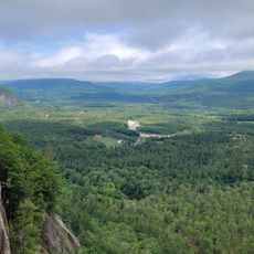
Black Cap, Mountain summit in North Conway, New Hampshire, US

Description

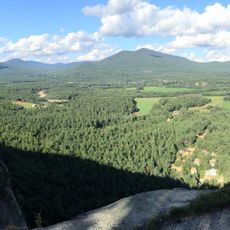
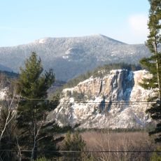
Black Cap is a mountain summit in North Conway, New Hampshire that rises above the surrounding forest. The hike leads through dense woods and opens onto exposed ledges where views extend across the valley and distant peaks.

History

The area became protected through land donations that secured its long-term preservation. An engraved stone at the summit marks the establishment of this protected land.

Culture

Local hiking groups maintain the paths year-round, organizing guided tours to educate visitors about the mountain's geological formations and wildlife.

Practical

Parking is available at the trailhead on Hurricane Mountain Road, and trail markers guide hikers throughout the walk. Check conditions before visiting, as seasonal changes can affect access on the exposed upper sections.

Did you know?

On clear days, visitors can see Mount Washington and other major peaks from the upper ledges. Many people come specifically for these distant views across multiple mountain ranges.

Location
GPS coordinates
44.05615,-71.06691
Latest update
December 13, 2025 11:41

AroundUs brings together thousands of curated places, local tips, and hidden gems, enriched daily by 60,000 contributors worldwide. Discover all places nearby (New Hampshire).

Around this place
Conway Scenic Railroad
United States of America

Conway Scenic Railroad

5 km
Story Land
United States of America

Story Land

11.4 km
Diana's Baths
United States of America

Diana's Baths

8.5 km
Echo Lake-Cathedral Ledge State Park
United States of America

Echo Lake-Cathedral Ledge State Park

7.2 km
United States of America

Roar-o-Saurus

11.2 km
Honeymoon Bridge
United States of America

Honeymoon Bridge

13.4 km
North Moat Mountain
United States of America

North Moat Mountain

11.9 km
Hemlock Bridge
United States of America

Hemlock Bridge

13.3 km
Abenaki Indian Shop and Camp
United States of America

Abenaki Indian Shop and Camp

5.9 km
Osgood Family House
United States of America

Osgood Family House

8.1 km
Squire Chase House
United States of America

Squire Chase House

8.3 km
Fryeburg Registry of Deeds
United States of America

Fryeburg Registry of Deeds

8.1 km
Rivercroft Farm
United States of America

Rivercroft Farm

7.7 km
Jackson Falls National Register Historic District
United States of America

Jackson Falls National Register Historic District

13.7 km
William K. Eastman House
United States of America

William K. Eastman House

9.7 km
Main Street Historic District
United States of America

Main Street Historic District

8.2 km
Conway Public Library
United States of America

Conway Public Library

9.5 km
Marion Parsons House
United States of America

Marion Parsons House

8.1 km
Barrows-Steadman Homestead
United States of America

Barrows-Steadman Homestead

8.2 km
Former Fryeburg Town House
United States of America

Former Fryeburg Town House

9.9 km
Majestic Theatre
United States of America

Majestic Theatre

9.6 km
Benjamin Wiley House
United States of America

Benjamin Wiley House

10 km
Fryeburg Public Library
United States of America

Fryeburg Public Library

8.2 km
Swift River Bridge
United States of America

Swift River Bridge

9 km
Pequawket Fire Tower
United States of America

Pequawket Fire Tower

5.9 km
Cathedral Ledge
United States of America

Cathedral Ledge

8.1 km
Albany Bridge
United States of America

Albany Bridge

15 km
Saco River Bridge
United States of America

Saco River Bridge

9.1 km
Show the full map
« Black Cap - Mountain summit in North Conway, New Hampshire, US » is provided by Around Us (aroundus.com). Images and texts are derived from Wikimedia project under a Creative Commons license. You are allowed to copy, distribute, and modify copies of this page, under the conditions set by the license, as long as this note is clearly visible.

Discover hidden gems everywhere you go!

From secret cafés to breathtaking viewpoints, skip the crowded tourist spots and find places that match your style. Our app makes it easy with voice search, smart filtering, route optimization, and insider tips from travelers worldwide. Download now for the complete mobile experience.

Around Us App Screenshot

A unique approach to discovering new places

Le Figaro

All the places worth exploring

France Info

A tailor-made excursion in just a few clicks

20 Minutes

Around Us
Travel Guide & Maps
Download

Send to your phone

QR Code
1

Open the camera app on your mobile.

2

Point at the QR code with your camera. A notification will appear.

3

Tap the notification to open the link.