Enable Location

We need your location to show you interesting places around you

Discover nearby places

Find interesting locations and hidden gems around you

Precise directions

Get accurate directions and distances to places

Your location is never shared with other users. It's only used when you tap the location button.

Bridge of Dreams

Log in to your account

Start exploring — it's free

Trusted by 61,867 travelers worldwide

Continue with Google
Continue with Apple
or

We will send you a code to connect

By continuing, you accept our Terms and Conditions and our Privacy Policy

Check your inbox

We've sent a pincode in your inbox. Please enter the code below.

Bridge of Dreams

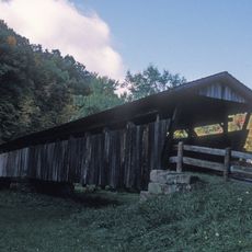
Bridge of Dreams, Covered railway bridge in Brinkhaven, Ohio, US.

Bridge of Dreams is a covered railway crossing over the Mohican River with a wooden structure built on original steel beams from the 1920s. The passage stretches about 370 feet (113 meters) and now carries pedestrians and cyclists where trains once ran.

The Pennsylvania Railway built this bridge in the 1920s as part of a line connecting Cleveland, Akron, and Columbus. In 1998, local residents converted the abandoned railway into a public pedestrian path.

The name came from locals who refused to give up on their vision to turn the old railway bridge into a pedestrian passage. Walking across it today, you can sense the community pride behind this conversion.

The crossing is located on Hunter Road and connects to the 4.5-mile Mohican Valley Trail for exploring the surrounding area. Parking is available underneath the structure at the trailhead, making access straightforward for day visitors.

The crossing welcomes Amish horse-drawn buggies alongside regular foot traffic, creating an interesting mix of modern and traditional travel. It ranks as the second-longest covered bridge in Ohio.

The community of curious travelers

AroundUs brings together thousands of curated places, local tips, and hidden gems, enriched daily by 60,000 contributors worldwide.

Start exploring
Location
GPS coordinates
40.46510,-82.19390
Latest update
December 10, 2025 20:05
Around this place
Kenyon College
United States of America

Kenyon College

20 km
Mohican State Park
United States of America

Mohican State Park

17.1 km
Brown's Lake Bog
United States of America

Brown's Lake Bog

26.5 km
Holmes County Courthouse
United States of America

Holmes County Courthouse

25.4 km
Helmick Covered Bridge
United States of America

Helmick Covered Bridge

22.7 km
United States of America

Welling Site

18.2 km
Raleigh Mound
United States of America

Raleigh Mound

29.6 km
Brightman House
United States of America

Brightman House

25.8 km
Ohio Theatre
United States of America

Ohio Theatre

19.4 km
Pomerene House
United States of America

Pomerene House

25.4 km
Christ Church at the Quarry
United States of America

Christ Church at the Quarry

17.3 km
United States of America

G. Adams House

25.5 km
Croco House
United States of America

Croco House

29.5 km
Millersburg Christian Church
United States of America

Millersburg Christian Church

25.5 km
United Methodist Church
United States of America

United Methodist Church

25.4 km
Malabar Farm State Park
United States of America

Malabar Farm State Park

26.4 km
Mohican-Memorial State Forest Fire Tower
United States of America

Mohican-Memorial State Forest Fire Tower

18.1 km
Knox County Courthouse
United States of America

Knox County Courthouse

25.7 km
Duncan Theater
United States of America

Duncan Theater

18.1 km
East High Street Historic District
United States of America

East High Street Historic District

25.5 km
East Gambier Street Historic District
United States of America

East Gambier Street Historic District

25.8 km
North Main-North Gay Streets Historic District
United States of America

North Main-North Gay Streets Historic District

25.8 km
Premiere Theatre 7
United States of America

Premiere Theatre 7

21.9 km
Vine Theatre
United States of America

Vine Theatre

25.9 km
Kenyon College Palme house
United States of America

Kenyon College Palme house

20 km
Mt Vernon & Knox County, Public Library Of
United States of America

Mt Vernon & Knox County, Public Library Of

26 km
Charles Franklin Kettering
United States of America

Charles Franklin Kettering

19.2 km
Christ Church at the Quarry January 18, 1863
United States of America

Christ Church at the Quarry January 18, 1863

17.3 km
Show the full map
« Bridge of Dreams - Covered railway bridge in Brinkhaven, Ohio, US » is provided by Around Us (aroundus.com). Images and texts are derived from Wikimedia project under a Creative Commons license. You are allowed to copy, distribute, and modify copies of this page, under the conditions set by the license, as long as this note is clearly visible.

Discover hidden gems everywhere you go!

From secret cafés to breathtaking viewpoints, skip the crowded tourist spots and find places that match your style. Our app makes it easy with voice search, smart filtering, route optimization, and insider tips from travelers worldwide. Download now for the complete mobile experience.

Around Us App Screenshot

A unique approach to discovering new places

Le Figaro

All the places worth exploring

France Info

A tailor-made excursion in just a few clicks

20 Minutes

Around Us
Travel Guide & Maps
Download

Send to your phone

QR Code
1

Open the camera app on your mobile.

2

Point at the QR code with your camera. A notification will appear.

3

Tap the notification to open the link.