Boone's Lick State Historic Site

Log in to your account

AroundUs is a community-driven map of interesting places, built by curious explorers like you. It grows with every review, story, and photo you share.
Connect to save your favorite spots, contribute locations, and create personalized routes.
Continue with Google
Continue with Apple
Continue with X
Continue with Facebook
Continue with email
By continuing, you accept our Terms and Conditions and our Privacy Policy
Create an account

Boone's Lick State Historic Site

Add to collection
Map
Suggest a change
Share

Boone's Lick State Historic Site, Salt production historic site in Howard County, Missouri.

Boone's Lick State Historic Site is a protected area in Howard County preserving remains of early salt production facilities from the 1800s. The location features wooden structures along Salt Creek and a large cast iron kettle that demonstrates how settlers processed salt from natural mineral springs.

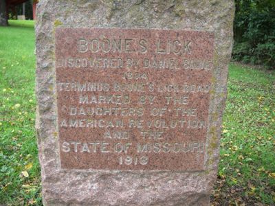
Nathan and Daniel Morgan Boone, sons of frontiersman Daniel Boone, established a salt production operation at natural springs in 1806. The facility became an important economic center that encouraged further settlement and development in the region.

The site represents an important place in early Missouri settlement, where people learned to extract salt from natural springs using industrial methods. This knowledge and production became central to the region's economic growth during the frontier period.

The 52-acre site offers hiking trails that lead through the landscape where production once occurred, with outdoor displays explaining frontier-era salt extraction methods. The paths are accessible to visitors interested in walking at a moderate pace and learning about historical techniques.

Three natural salt springs converge to form Salt Creek, where mineral deposits continuously accumulate in the water and soil. This steady mineral source made the location valuable for both wildlife and early industrial salt production.

Location: Missouri

GPS coordinates: 39.08220,-92.87920

Latest update: December 12, 2025 07:52

Photos
Around this place
Arrow Rock State Historic Site
United States of America

Arrow Rock State Historic Site

10.7 km
Arrow Rock Historic District
United States of America

Arrow Rock Historic District

5.9 km
J. Huston Tavern
United States of America

J. Huston Tavern

5.9 km
George Caleb Bingham House
United States of America

George Caleb Bingham House

5.7 km
Glasgow Railroad Bridge
United States of America

Glasgow Railroad Bridge

15.8 km
Greenwood
United States of America

Greenwood

11.3 km
Thomas Nelson House
United States of America

Thomas Nelson House

17.4 km
Glasgow Bridge, Missouri
United States of America

Glasgow Bridge, Missouri

15.8 km
Cedar Grove
United States of America

Cedar Grove

10.6 km
Glasgow Presbyterian Church
United States of America

Glasgow Presbyterian Church

16.4 km
Campbell Chapel African Methodist Episcopal Church
United States of America

Campbell Chapel African Methodist Episcopal Church

16.4 km
William B. Sappington House
United States of America

William B. Sappington House

10.3 km
Lyric Theater
United States of America

Lyric Theater

16.9 km
St. Matthew's Chapel A.M.E. Church
United States of America

St. Matthew's Chapel A.M.E. Church

17 km
Glasgow Public Library
United States of America

Glasgow Public Library

16.3 km
Blackwater Residential Historic District
United States of America

Blackwater Residential Historic District

14.9 km
Roeschel-Toennes-Oswald Property
United States of America

Roeschel-Toennes-Oswald Property

16.2 km
Harris-Chilton-Ruble House
United States of America

Harris-Chilton-Ruble House

13.8 km
Edwin and Nora Payne Bedford House
United States of America

Edwin and Nora Payne Bedford House

9.9 km
Historic District D
United States of America

Historic District D

16.7 km
Albert Gallatin Blakey House
United States of America

Albert Gallatin Blakey House

16.3 km
Meierhoffer Sand Company Office Building
United States of America

Meierhoffer Sand Company Office Building

16.3 km
Andrews-Wing House
United States of America

Andrews-Wing House

17.1 km
William S. and Mary Beckett House
United States of America

William S. and Mary Beckett House

17.1 km
Sumner Public School
United States of America

Sumner Public School

17.1 km
New Franklin Commercial Historic District
United States of America

New Franklin Commercial Historic District

14.3 km
Historic District C
United States of America

Historic District C

16.5 km
Boonslick Bridge
United States of America

Boonslick Bridge

16.1 km
Show the full map
Reviews

Visited this place? Tap the stars to rate it and share your experience / photos with the community! Try now! You can cancel it anytime.

« Boone's Lick State Historic Site - Salt production historic site in Howard County, Missouri » is provided by Around Us (aroundus.com). Images and texts are derived from Wikimedia project under a Creative Commons license. You are allowed to copy, distribute, and modify copies of this page, under the conditions set by the license, as long as this note is clearly visible.

Discover hidden gems everywhere you go!

From secret cafés to breathtaking viewpoints, skip the crowded tourist spots and find places that match your style. Our app makes it easy with voice search, smart filtering, route optimization, and insider tips from travelers worldwide. Download now for the complete mobile experience.

Around Us App Screenshot

A unique approach to discovering new places

Le Figaro

All the places worth exploring

France Info

A tailor-made excursion in just a few clicks

20 Minutes