Chest opened
+${chestReward.xp} XP
Explorer
NOUVEAU ×${chestReward.collectible.quantity}
tapez pour fermer
Chest locked

Open chests in the app

Around Us is built for your phone — chests unlock when you walk, explore and capture nearby places.

Enable Location

We need your location to show you interesting places around you

Discover nearby places

Find interesting locations and hidden gems around you

Precise directions

Get accurate directions and distances to places

Your location is never shared with other users. It's only used when you tap the location button.

Log in to your account

Start exploring — it's free

Trusted by 72,923 travelers worldwide

Continue with Google
Continue with Apple
or

We will send you a code to connect

By continuing, you accept our Terms and Conditions and our Privacy Policy

Check your inbox

We've sent a pincode in your inbox. Please enter the code below.

Dead Timber State Recreation Area
Discussion Reviews Photo
1.5k Popularity

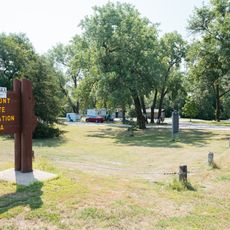
Dead Timber State Recreation Area, Recreation area in Dodge County, Nebraska

Dead Timber State Recreation Area is a recreation area in Dodge County, Nebraska situated between the Elkhorn River and an oxbow lake created by the river's natural curves. Visitors find forested sections, open meadows, and developed zones with shelters and camping areas throughout the property.

The site was developed by the National Youth Association in 1939, which built a stone shelter and entrance pillars that still stand today. These structures have survived numerous flooding events over the decades and remain key features of the landscape.

Local residents maintain connections to the area by volunteering their time to perform maintenance tasks and preserve the recreational facilities for future generations.

The area provides campsites with electrical hookups and day-use shelters equipped with tables and grills for outdoor groups. These facilities make it easy to spend time outdoors, whether camping for a night or stopping by for a day visit.

The name comes from a Native American winter camp where a fire destroyed large amounts of timber in the surrounding forest long ago. This story connects the modern landscape to the events that shaped it.

The community of curious travelers

AroundUs brings together thousands of curated places, local tips, and hidden gems, enriched daily by 60,000 contributors worldwide.

Start exploring
Location
GPS coordinates
41.71670,-96.69190
Latest update
December 14, 2025 14:42
Around this place
Christ the King Priory
United States of America

Christ the King Priory

38 km
Fremont Lakes State Recreation Area
United States of America

Fremont Lakes State Recreation Area

31.3 km
St. John's German Evangelical Lutheran Church
United States of America

St. John's German Evangelical Lutheran Church

28.5 km
John G. Neihardt State Historic Site
United States of America

John G. Neihardt State Historic Site

34.2 km
Nye House
United States of America

Nye House

34.1 km
Zion Presbyterian Church
United States of America

Zion Presbyterian Church

30.7 km
Swedish Heritage Center
United States of America

Swedish Heritage Center

23.2 km
J. D. McDonald House
United States of America

J. D. McDonald House

35.3 km
Clarkson Opera House
United States of America

Clarkson Opera House

35.8 km
Rattlesnake Creek Bridge
United States of America

Rattlesnake Creek Bridge

37 km
West Point City Auditorium
United States of America

West Point City Auditorium

14 km
Love-Larson Opera House
United States of America

Love-Larson Opera House

35.3 km
George and Nancy Turner House
United States of America

George and Nancy Turner House

36 km
Rad Plzen cis. 9 Z.C.B.J.
United States of America

Rad Plzen cis. 9 Z.C.B.J.

32.4 km
Schneider's Opera House
United States of America

Schneider's Opera House

8.2 km
Fremont Municipal Auditorium
United States of America

Fremont Municipal Auditorium

35 km
Dodge County Courthouse
United States of America

Dodge County Courthouse

35.5 km
E.C. Houston House
United States of America

E.C. Houston House

39.8 km
Tekamah Carnegie Library
United States of America

Tekamah Carnegie Library

39.6 km
North Bend Carnegie Library
United States of America

North Bend Carnegie Library

29.1 km
R. B. Schneider House
United States of America

R. B. Schneider House

34.8 km
Fontanelle Township Hall
United States of America

Fontanelle Township Hall

29.7 km
Frank Uehling Barn
United States of America

Frank Uehling Barn

16 km
Burt County Courthouse
United States of America

Burt County Courthouse

39.8 km
Burt County State Bank
United States of America

Burt County State Bank

39.6 km
Samuel Bullock House
United States of America

Samuel Bullock House

35 km
Hooper Historic District
United States of America

Hooper Historic District

16.8 km
Tekamah City Bridge
United States of America

Tekamah City Bridge

39.7 km
Show the full map
Reviews
Share your experience

No review yet

Discussions
Start a discussion...

No discussion yet

« Dead Timber State Recreation Area - Recreation area in Dodge County, Nebraska » is provided by Around Us (aroundus.com). Images and texts are derived from Wikimedia project under a Creative Commons license. You are allowed to copy, distribute, and modify copies of this page, under the conditions set by the license, as long as this note is clearly visible.

Discover hidden gems everywhere you go!

From secret cafés to breathtaking viewpoints, skip the crowded tourist spots and find places that match your style. Our app makes it easy with voice search, smart filtering, route optimization, and insider tips from travelers worldwide. Download now for the complete mobile experience.

Around Us App Screenshot

A unique approach to discovering new places

Le Figaro

All the places worth exploring

France Info

A tailor-made excursion in just a few clicks

20 Minutes

Around Us
Travel Guide & Maps
Download

Send to your phone

QR Code
1

Open the camera app on your mobile.

2

Point at the QR code with your camera. A notification will appear.

3

Tap the notification to open the link.