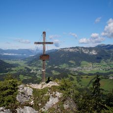
Grimming, Mountain summit in Dachstein Mountains, Austria
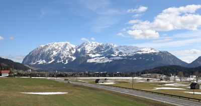
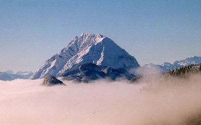
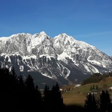
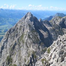
Grimming is an isolated limestone peak that rises to 2,351 meters and stands alone between the Enns valley and the Salzkammergut region. The rocky surface displays typical limestone formations, and the summit area offers views across the valleys on both sides.
The mountain was surveyed in 1822 by Lieutenant Carl Baron Simbschen, who placed a wooden mark at the summit. This early marking was part of the scientific exploration of the Alpine region during the 19th century.
The Grimmingtor is a natural rock gate that holds a special place in local stories and folklore. Visitors can see this distinctive opening in the rock face as they climb, and it remains a memorable landmark that connects the mountain to the region's traditions.
The climb to the summit is demanding and requires endurance and safe movement over steep terrain. Sturdy boots and mountaineering experience are needed to navigate the route safely.
The peak stands out markedly from its surroundings with a prominence of over 1,500 meters. This substantial rise above neighboring summits makes it geologically distinctive in the Alpine landscape.
Location: Stainach-Pürgg
Location: Mitterberg-Sankt Martin
Location: Bad Mitterndorf
Elevation above the sea: 2,351 m
Made from material: limestone
GPS coordinates: 47.52069,14.01711
Latest update: December 7, 2025 10:04
Schloss Trautenfels
4.8 km
Salza-Stausee
5.7 km
Saint John the Evangelist Chapel
4.1 km
Saint George Church
3.9 km
Trautenfels Castle
4.8 km
Toni Adam-Dr.-Obersteiner-Biwak
211 m
Pfarrkirche zum Heiligen Kreuz, Tauplitz
4.5 km
Parish church Sankt Martin am Grimming
4.4 km
Kirchenruine Neuhaus (Trautenfels)
3.9 km
Friedhof christlich
3.9 km
Singerkapelle
2.8 km
Ortskapelle, Trummer-Kapelle
5 km
Bauernhaus, Raudaschl
2.6 km
Universalmuseum Joanneum: Trautenfels Castle
4.8 km
Trautenfels Castle - war memorial
4.9 km
Bahnhof Trautenfels
5.1 km
Pfarrhof Pürgg
3.9 km
Ehemaliger Zehentspeicher Stainach
5.7 km
Brunnenhaus
4.4 km
Fleischhackerhaus, Pürgg
4 km
Altersheim, Gräfin Anna Lamberg-Stiftung
4.4 km
Steinfeldspitze
1.3 km
Bastionen von Schloss Trautenfels
4.9 km
Zufahrtsflankierung
4.8 km
Gindlhorn
4 km
Volksschule
3.9 km
Schartenspitze
944 m
Prähistorische Höhensiedlung am Burgstall bei Pürgg
3.6 kmVisited this place? Tap the stars to rate it and share your experience / photos with the community! Try now! You can cancel it anytime.
Discover hidden gems everywhere you go!
From secret cafés to breathtaking viewpoints, skip the crowded tourist spots and find places that match your style. Our app makes it easy with voice search, smart filtering, route optimization, and insider tips from travelers worldwide. Download now for the complete mobile experience.
A unique approach to discovering new places❞
— Le Figaro
All the places worth exploring❞
— France Info
A tailor-made excursion in just a few clicks❞
— 20 Minutes