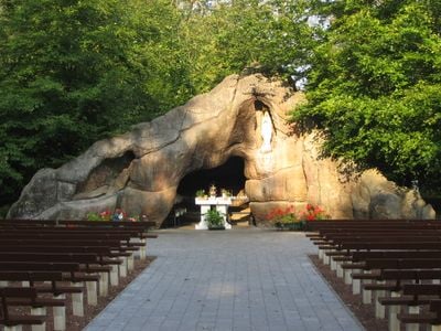
Lourdesgrot, cave in Humbeek, Belgium
Lourdesgrot is a prayer site in Grimbergen located in a quiet area near the 's Gravenbos forest. The site features a small chapel with a statue of Mary and is surrounded by green trees that create a peaceful, secluded setting.
The site was built in the early 1950s following a pilgrimage to Lourdes in 1952 that inspired visitors to create a similar space in their community. The official opening took place on August 15, 1954, and was led by Monseigneur Cardijn, a prominent church leader.
The name references the sanctuary of Lourdes in France and reflects local devotion to Mary. Visitors leave flowers and light candles here, gestures that show how the site remains woven into everyday community life.
The site has no admission fee and is open year-round, making it an easily accessible stop for pilgrims and locals alike. Benches are available for sitting, and the place welcomes anyone seeking a moment of quiet reflection.
In 2014 the statue of Mary was stolen, prompting a renewed community effort to procure a replacement from Lourdes and restore the site. This event revealed how deeply the place is connected to the local people and their willingness to rebuild it together.
The community of curious travelers
AroundUs brings together thousands of curated places, local tips, and hidden gems, enriched daily by 60,000 contributors worldwide.