Ebro Reservoir, Water reservoir between Cantabria and Burgos, Spain
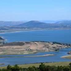
The Ebro Reservoir is a water reservoir between the provinces of Burgos and Cantabria, surrounded by meadows, oak forests, and mountains. The water stretches over 22 kilometers and forms a boundary between two regions in northern Spain.
Built between 1921 and 1945 and inaugurated in 1952, the reservoir flooded the fertile La Rasa de Campoo plain, completely submerging Medianedo, La Magdalena, Quintanilla and Quintanilla de Bustamante, while other villages were partly flooded and rebuilt on the shore. Expropriations were carried out in 1932 by the Confederación Hidrográfica del Ebro under the 1879 Expropriation Law. Of the promised compensations, only the Noguerol bridge was built, and it collapsed shortly after.
The reservoir is also called pantano de Reinosa or pantano de Arija, after the towns on its shores. In summer its waters host kayaking, kitesurfing and especially windsurfing, favoured by winds that blow mainly over the eastern part. Cattle and horses graze the fertile shore pastures exposed when the water drops.
The roads around the reservoir are easy to drive and allow a complete loop in about one hour. Several points offer parking and viewpoints that make access to the shore easier.
The reservoir flooded the fertile La Rasa de Campoo meadow, submerging the villages of Medianedo, La Magdalena, Quintanilla and Quintanilla de Bustamante completely, while many other settlements were partly flooded and rebuilt on the shore. Of the promised compensations, only the Noguerol bridge was built, and it collapsed from structural problems shortly after.
The community of curious travelers
AroundUs brings together thousands of curated places, local tips, and hidden gems, enriched daily by 93,530 contributors worldwide.