Chest opened
+${chestReward.xp} XP
Explorer
NOUVEAU ×${chestReward.collectible.quantity}
tapez pour fermer

See the monuments around you in AR Open chests in the app

Around Us is built for your phone — point your camera at the streets and discover the monuments and places around you in augmented reality. Around Us is built for your phone — chests unlock when you walk, explore and capture nearby places.

•

Enable Location

We need your location to show you interesting places around you

Discover nearby places

Find interesting locations and hidden gems around you

Precise directions

Get accurate directions and distances to places

Your location is never shared with other users. It's only used when you tap the location button.

Turó de la Magarola

Log in to your account

Start exploring — it's free

Trusted by 93,951 travelers worldwide

Continue with Google
Continue with Apple
or

We will send you a code to connect

By continuing, you accept our Terms and Conditions and our Privacy Policy

Check your inbox

We've sent a pincode in your inbox. Please enter the code below.

Turó de la Magarola

Turó de la Magarola, Summit in the Serra de Collserola, Spain

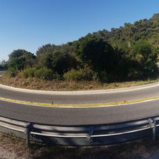
Turó de la Magarola is a 430-metre summit in the Serra de Collserola, at the point where the municipal boundaries of Barcelona, Cerdanyola del Vallès and Sant Cugat del Vallès meet. A geodetic vertex marks the top, where a wooden platform with information panels was built for bird-migration observers.

The name Magarola is documented in 985 as "Magerova" or "Magarova", referring to another place near Sant Cugat del Vallès. A Barcelona bourgeois family later adopted the name and applied it to several sites they owned, beginning with the Magarola palace on Carrer Portaferrissa. The hill itself is included in the FEEC's list of 100 summits as Turó de Magarola.

Since 1988, volunteers have recorded the autumn raptor migration here in September and October from a wooden platform with information panels built at the summit. The most frequently counted species is the European honey buzzard, followed by the common kestrel and the western marsh harrier.

Hikers can reach the summit through various trails, including the long-distance GR 92 and GR 6 paths that connect to other peaks in the region. The routes are well marked, though sturdy footwear is advisable due to uneven ground.

The site functions as a monitoring station for bird migration, recording thousands of passing raptors annually during their journey. This makes it a valuable location for tracking bird movement patterns and population trends scientifically.

The community of curious travelers

AroundUs brings together thousands of curated places, local tips, and hidden gems, enriched daily by 93,951 contributors worldwide.

Start exploring
GPS coordinates
41.44215,2.12969
Latest update
October 31, 2026 17:05
Reviews
Share your experience

No review yet

Discussions
Start a discussion...

No discussion yet

« Turó de la Magarola - Summit in the Serra de Collserola, Spain » is provided by Around Us (aroundus.com). Images and texts are derived from Wikimedia project under a Creative Commons license. You are allowed to copy, distribute, and modify copies of this page, under the conditions set by the license, as long as this note is clearly visible.

Discover hidden gems everywhere you go!

From secret cafés to breathtaking viewpoints, skip the crowded tourist spots and find places that match your style. Our app makes it easy with voice search, smart filtering, route optimization, and insider tips from travelers worldwide. Download now for the complete mobile experience.

Around Us App Screenshot
❝

A unique approach to discovering new places❞

— Le Figaro

❝

All the places worth exploring❞

— France Info

❝

A tailor-made excursion in just a few clicks❞

— 20 Minutes

Around Us
Travel Guide & Maps
Download

Send to your phone

QR Code
1

Open the camera app on your mobile.

2

Point at the QR code with your camera. A notification will appear.

3

Tap the notification to open the link.