·

Enable Location

We need your location to show you interesting places around you

Discover nearby places

Find interesting locations and hidden gems around you

Precise directions

Get accurate directions and distances to places

Your location is never shared with other users. It's only used when you tap the location button.

Grüner See

Log in to your account

Start exploring — it's free

Trusted by 62,645 travelers worldwide

Continue with Google
Continue with Apple
or

We will send you a code to connect

By continuing, you accept our Terms and Conditions and our Privacy Policy

Check your inbox

We've sent a pincode in your inbox. Please enter the code below.

Grüner See

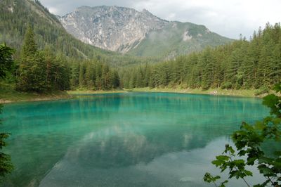
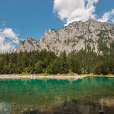
Grüner See, Mountain lake in Tragöß-Sankt Katharein, Austria.

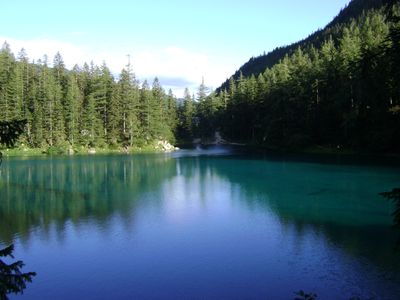
Grüner See sits at 776 meters elevation in the Hochschwab range of Styria and can reach depths up to 12 meters. The basin fills each year with meltwater from the surrounding karst slopes, flooding paths and park benches.

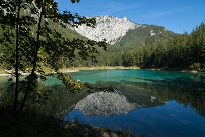
The basin was originally a grazing meadow that became a local recreation area in the 19th century. In 2016, authorities introduced a complete ban on water activities to protect the natural cycle.

Local people call this place Grüner See because of the translucent color that comes from dissolved minerals in the limestone. Visitors arrive here to see how the water transforms the dry meadow into a flooded basin each year.

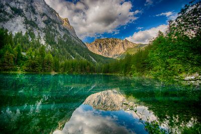
Visitors who want to see the flooded landscape should arrive between mid-May and June when snowmelt reaches its peak. Outside these months, the area appears as a dry park with walking trails.

In winter, the water level drops to 1 or 2 meters, and the surrounding area turns back into a walkable park with dry paths. This seasonal transformation makes the lake an unusual natural phenomenon in the Alps.

The community of curious travelers

AroundUs brings together thousands of curated places, local tips, and hidden gems, enriched daily by 60,000 contributors worldwide.

Start exploring
Elevation above the sea
776 m
Address
Grüner See, 8612, Austria
GPS coordinates
47.54167,15.05583
Latest update
January 22, 2026 09:48
Hidden places in Austria

Austria extends well beyond Vienna and Salzburg. Away from major tourist routes lie natural monuments and historical sites that reveal the country's geological and cultural heritage. From the Eisriesenwelt ice caves near Werfen to medieval castles such as Hochosterwitz in Carinthia, this collection...

Styria: Graz, mountain ranges, castles and vineyards

Styria: Graz, mountain ranges, castles and vineyards. In Graz, the old center is easy to walk through. You see narrow streets, the church of Saint Aegidius and the Eggenberg Palace. The Palace is old and has gardens. On the hill called Schlossberg, the clock tower gives a view over the rooftops. The...

« Grüner See - Mountain lake in Tragöß-Sankt Katharein, Austria » is provided by Around Us (aroundus.com). Images and texts are derived from Wikimedia project under a Creative Commons license. You are allowed to copy, distribute, and modify copies of this page, under the conditions set by the license, as long as this note is clearly visible.

Discover hidden gems everywhere you go!

From secret cafés to breathtaking viewpoints, skip the crowded tourist spots and find places that match your style. Our app makes it easy with voice search, smart filtering, route optimization, and insider tips from travelers worldwide. Download now for the complete mobile experience.

Around Us App Screenshot

A unique approach to discovering new places

Le Figaro

All the places worth exploring

France Info

A tailor-made excursion in just a few clicks

20 Minutes

Around Us
Travel Guide & Maps
Download

Send to your phone

QR Code
1

Open the camera app on your mobile.

2

Point at the QR code with your camera. A notification will appear.

3

Tap the notification to open the link.