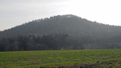
Kohlbornstein, Summit in Gohrisch, Germany.
Kohlbornstein is a peak in Saxon Switzerland that rises 378 meters above sea level and displays sandstone formations from the Postelwitz and Schrammstein geological layers. The surface shows the typical reddish and yellowish tones of this rock formation, shaped over millennia by wind and water.
In 1884, the Mountain Association of Saxon Switzerland built a path to the summit, making the peak more accessible to hikers. The area later became a popular destination for outdoor outings.
The Malerweg hiking route passes near this summit, linking villages through the Elbe Sandstone Mountains and attracting walkers who want to explore the regional landscape. Local visitors frequently incorporate this trail into longer journeys across the area.
Access to the summit is only from the southwest side, with the path covering about 11 kilometers and taking roughly 3 to 4 hours. Hikers should bring sturdy shoes and plenty of water.
The name Kohlbornstein comes from a spring called Kohlborn located at the northern base of the peak, where water emerges directly from the sandstone formations. This natural water source was an important stop for early climbers during long hikes.
The community of curious travelers
AroundUs brings together thousands of curated places, local tips, and hidden gems, enriched daily by 60,000 contributors worldwide.