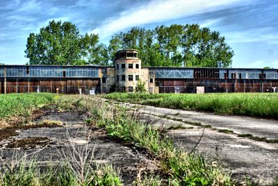
Flugplatz Rangsdorf, Former military airfield in Rangsdorf, Germany
Flugplatz Rangsdorf is a former aerodrome located beside a lake with multiple hangars and maintenance buildings spread across the site. The facility features both conventional runway areas and water-based landing infrastructure.
The facility was built in 1935 to support Olympic aviation events. After 1945 it came under Soviet control and operated as a military base until 1994.
The site's name reflects its location near the lake and served as a hub for aviation pioneers. Visitors can still sense the connection to flight history while walking across the grounds.
The site is protected as a heritage monument and large portions are being converted into educational facilities and residential areas. Visitors should note that not all areas are freely accessible.
The location is known as the departure point for a significant flight on July 20, 1944, when an attempt was made to overturn the political leadership. This event made the site an important place in the history of resistance movements.
Location: Rangsdorf
GPS coordinates: 52.28250,13.42889
Latest update: December 10, 2025 15:58
Gutsanlage Dahlewitz
4.4 km
Rangsdorfer See
2.3 km
Groß-Machnower Weinberg
5.3 km
Zülowgrabenniederung
3.6 km
Gutshaus Groß Machnow
2.6 km
Dorfkirche Jühnsdorf
3.7 km
Village church Rangsdorf
1.2 km
Gutshaus Jühnsdorf
3.6 km
Ehemaliger Blankenfelder See
4 km
Dorfkirche Glienick
4.9 km
Village church Dahlewitz
4.4 km
Machnower See
1.5 km
Village church Groß Machnow
2.6 km
Glasowbachniederung
2.5 km
Dorfkirche Groß Schulzendorf
5.3 km
Dorfkirche Groß Kienitz
5.3 km
Wein-Berg
5.3 km
Großmachnower Weinberg
5.4 km
Zülow-Niederung
661 m
Wohnhaus Bruno Taut
5.4 km
Dünen Dabendorf
4.2 km
Naturdenkmal Düne Heideweg
4.2 km
Naturdenkmal Weiße Maulbeere (Morus alba) (Baum) im Gutshof, SW Kirche; Flur 4, Flurstück 948 in Groß Machnow
2.6 km
Naturdenkmal Linde
4.9 km
Naturdenkmal Stieleiche (Quercus robur) (Baumgruppe) 0,6 km NW Bahnhof, Triftstraße/Rangsdorfer Straße, vor Schule; Flur 5, Flurstück 201 in Dabendorf
4.5 km
Naturdenkmal Baumgruppe Eichen und Linden am Kriegsdenkmal Groß Machnow
2.6 km
Kopfweidenallee Groß Machnow
2.2 km
Wasserturm Dahlewitz
4.5 kmVisited this place? Tap the stars to rate it and share your experience / photos with the community! Try now! You can cancel it anytime.
Discover hidden gems everywhere you go!
From secret cafés to breathtaking viewpoints, skip the crowded tourist spots and find places that match your style. Our app makes it easy with voice search, smart filtering, route optimization, and insider tips from travelers worldwide. Download now for the complete mobile experience.
A unique approach to discovering new places❞
— Le Figaro
All the places worth exploring❞
— France Info
A tailor-made excursion in just a few clicks❞
— 20 Minutes