Enable Location

We need your location to show you interesting places around you

Discover nearby places

Find interesting locations and hidden gems around you

Precise directions

Get accurate directions and distances to places

Your location is never shared with other users. It's only used when you tap the location button.

Fort Kléber

Log in to your account

Start exploring — it's free

Trusted by 63,342 travelers worldwide

Continue with Google
Continue with Apple
or

We will send you a code to connect

By continuing, you accept our Terms and Conditions and our Privacy Policy

Check your inbox

We've sent a pincode in your inbox. Please enter the code below.

Discussion Reviews 1 Photos
1.1k Popularity

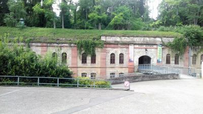
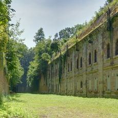
Fort Kléber, ouvrage de la ceinture fortifiée de Strasbourg (1875-1888)

Fort Kléber is a fortified structure in Wolfisheim with a low irregular hexagonal shape, thick stone and brick walls, and a deep dry moat about 20 feet (6 meters) wide. Inside, it contains firing platforms for artillery, narrow defensive corridors, casemates for soldiers, and ammunition storage rooms connected by covered passages.

Built between 1872 and 1875 by Germans who had taken control of Strasbourg in 1870, it was designed to defend the city from attacks coming from the north or south. France renamed it Fort Kléber in 1918 and took control after the First World War.

The fort's name honours Jean-Baptiste Kléber, a French general, chosen in 1918 after the French reclaimed the area. Today it serves as a public park where people can walk around the historic walls and learn about the region's shared past through guided tours and open exploration.

The fort's outdoor areas are open for exploration, but the site is closed to the public from September 2024 for maintenance and safety work. There is a playground for children, a walking trail through the old moat, and a small farm animal enclosure, making it a place for families of different ages.

The fort was originally called Fort VI and was designed by General Hans Alexis von Biehler using an innovative layout that spread multiple forts across a wider area for better coverage. Despite plans for at least 36 forts, only about 14 were actually built in the region.

The community of curious travelers

AroundUs brings together thousands of curated places, local tips, and hidden gems, enriched daily by 60,000 contributors worldwide.

Start exploring
Location
Inception
1875
GPS coordinates
48.58992,7.66277
Latest update
February 9, 2026 07:44
Reviews
Share your experience

No review yet

Discussions
Start a discussion...

No discussion yet

« Fort Kléber - ouvrage de la ceinture fortifiée de Strasbourg (1875-1888) » is provided by Around Us (aroundus.com). Images and texts are derived from Wikimedia project under a Creative Commons license. You are allowed to copy, distribute, and modify copies of this page, under the conditions set by the license, as long as this note is clearly visible.

Discover hidden gems everywhere you go!

From secret cafés to breathtaking viewpoints, skip the crowded tourist spots and find places that match your style. Our app makes it easy with voice search, smart filtering, route optimization, and insider tips from travelers worldwide. Download now for the complete mobile experience.

Around Us App Screenshot

A unique approach to discovering new places

Le Figaro

All the places worth exploring

France Info

A tailor-made excursion in just a few clicks

20 Minutes

Around Us
Travel Guide & Maps
Download

Send to your phone

QR Code
1

Open the camera app on your mobile.

2

Point at the QR code with your camera. A notification will appear.

3

Tap the notification to open the link.