Fort de Montgilbert, Military fort in Montgilbert, France.
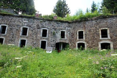
Fort de Montgilbert is a triangular fortification positioned at 1360 meters elevation in the Savoie department with multiple defensive structures arranged around a central courtyard. The complex includes barracks, ammunition storage facilities, and gun positions built into stone and earth.
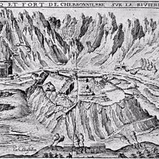
The fort was constructed between 1877 and 1882 as part of the Chamousset fortress system designed to control the Arc Valley. It was positioned as a strategic defensive line along important regional routes.
During World War II, the fort area became a resistance point, marked by a weapons airdrop operation on December 15, 1943.
Access is via hiking trails from the Les Bugnons hamlet following yellow markings through a forest path with approximately 450 meters of elevation gain. The hike is manageable on foot but requires proper gear and some stamina due to the climb.
The fort retains original features like a bread oven and period woodwork that show what life was like for the garrison. The powder magazine is particularly interesting for its specialized ventilation systems that prevented dangerous gas accumulation.
Location: Montgilbert
Elevation above the sea: 1,182 m
GPS coordinates: 45.52042,6.26227
Latest update: December 14, 2025 13:06
Château de Charbonnières
4.3 km
Fort d'Aiton
4.4 km
Abbaye du Betton
6.9 km
Pont Royal de Chamousset
6.8 km
Église Saint-Barthélémy de Montsapey
6 km
Tunnel hydraulique du Gelon
6.4 km
Église Saint-Maurice de Chamousset
6.5 km
Église Saint-Pierre de Montgilbert
3.7 km
Église Saint-Christophe d'Aiguebelle
4 km
Église Saint-Nicolas du Pontet
4 km
Église Saint-Pierre et Saint-Paul
7 km
Église de Saint-Alban-d'Hurtières
4.4 km
Église Saint-Laurent d'Aiton
4.5 km
Bourget-en-Huile - Chalet du Verney
5.9 km
Musée du Félicien
4.9 km
Église Sainte-Thècle de Bourget-en-Huile
5.9 km
Église Saint-Martin de Chamoux-sur-Gelon
4 km
Église de l'Assomption de Randens
4.6 km
Église Sainte-Madeleine d'Hauteville
7.1 km
Église Saint-Georges de Saint-Georges-d'Hurtières
2.8 km
Église de l'Assomption de Bourgneuf
5.2 km
Église Saint-Clair de Betton-Bettonet
6 km
Chapelle Notre-Dame-de-Lourdes de Bourget-en-Huile
5.6 km
Ancien temple protestant de Saint-Alban-d'Hurtières
4.4 km
Chapelle Saint-Joseph de Villard-Léger
5.9 km
Château de Chamoux
4 km
Château du Bettonet
6 km
Chapelle Notre-Dame-de-la-Salette de Saint-Alban-d'Hurtières
4.2 kmVisited this place? Tap the stars to rate it and share your experience / photos with the community! Try now! You can cancel it anytime.
Discover hidden gems everywhere you go!
From secret cafés to breathtaking viewpoints, skip the crowded tourist spots and find places that match your style. Our app makes it easy with voice search, smart filtering, route optimization, and insider tips from travelers worldwide. Download now for the complete mobile experience.
A unique approach to discovering new places❞
— Le Figaro
All the places worth exploring❞
— France Info
A tailor-made excursion in just a few clicks❞
— 20 Minutes