Tête de la Combaz, Mountain summit in Les Contamines-Montjoie, France
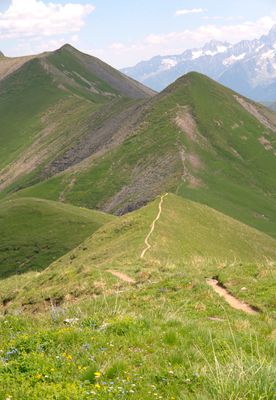
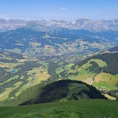
Tête de la Combaz is a mountain summit reaching 2445 meters in the Beaufortain massif, positioned to overlook the surrounding valleys and the Mont Blanc range. The peak sits within a landscape of alpine meadows and rock faces that can be reached by several hiking routes.
This peak has served as a landmark for shepherds and travelers crossing the Alps for many generations, marking an important mountain passage. The route through this area has been followed for centuries as people moved across the alpine terrain.
Local shepherds use the slopes during summer months to graze their herds following customs that have shaped the landscape for centuries. Visitors walking through can see this pastoral tradition in action and understand how people have lived and worked in these mountains.
The hike from Les Contamines-Montjoie is a full-day undertaking on mountain trails with steep sections and variable footing throughout. Good footwear, plenty of water, and an early start are important because daylight hours matter when the route takes most of the day.
In winter, the mountain slopes can be explored through ski touring, with routes starting from the lower hamlet of Baptieu. This shows how the mountain serves different purposes depending on the season and snow conditions.
Location: Les Contamines-Montjoie
Location: Saint-Gervais-les-Bains
Elevation above the sea: 2,445 m
GPS coordinates: 45.81721,6.68610
Latest update: December 14, 2025 20:22
Les Contamines-Montjoie / Hauteluce
3.6 km
Evasion Mont Blanc
1.4 km
Église Notre Dame de la Gorge, près des Contamines-Montjoie
3.6 km
Domaine du Mont d'Arbois
6.3 km
Mont Joly
1.1 km
Mont d'Arbois
4.4 km
Église Saint-Nicolas-de-Véroce de Saint-Gervais-les-Bains
5.1 km
Val Montjoie
5.2 km
Réserve naturelle nationale des Contamines-Montjoie
6.2 km
Aiguille de Roselette
5.2 km
Rochebrune
5.9 km
Téléphérique de Rochebrune
6.6 km
Parc de loisirs du Pontet
3.5 km
Chapelle des Plans
5.8 km
Chalets de Miage
6.3 km
Mont Joux
3.4 km
Croix du Christ
3 km
Ruisseau du Dorinet
5.6 km
Calvaire de Megève
6.3 km
Mont Géroux
2 km
Tête du Véleray
1.2 km
Chalets du Truc
5.4 km
Chalet Nant Rouge
2.8 km
Chapelle Sainte Anne de Megève
6.8 km
Torrent de Miage
4.8 km
Chapelle Notre-Dame-du-Mont-Carmel, Saint-Symphorien, Saint-Antoine-de-Padoue de la Combe
6.2 km
Le Hameau du Ptou
3.3 km
Pâturages de Miage
6.4 kmVisited this place? Tap the stars to rate it and share your experience / photos with the community! Try now! You can cancel it anytime.
Discover hidden gems everywhere you go!
From secret cafés to breathtaking viewpoints, skip the crowded tourist spots and find places that match your style. Our app makes it easy with voice search, smart filtering, route optimization, and insider tips from travelers worldwide. Download now for the complete mobile experience.
A unique approach to discovering new places❞
— Le Figaro
All the places worth exploring❞
— France Info
A tailor-made excursion in just a few clicks❞
— 20 Minutes