Chest opened
+${chestReward.xp} XP
Explorer
NOUVEAU ×${chestReward.collectible.quantity}
tapez pour fermer

See the monuments around you in AR Open chests in the app

Around Us is built for your phone — point your camera at the streets and discover the monuments and places around you in augmented reality. Around Us is built for your phone — chests unlock when you walk, explore and capture nearby places.

•

Enable Location

We need your location to show you interesting places around you

Discover nearby places

Find interesting locations and hidden gems around you

Precise directions

Get accurate directions and distances to places

Your location is never shared with other users. It's only used when you tap the location button.

Tsutashima

Log in to your account

Start exploring — it's free

Trusted by 93,783 travelers worldwide

Continue with Google
Continue with Apple
or

We will send you a code to connect

By continuing, you accept our Terms and Conditions and our Privacy Policy

Check your inbox

We've sent a pincode in your inbox. Please enter the code below.

Tsutashima

Tsutashima, Desert island in Ōita, Japan

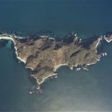
Tsutashima is an uninhabited island in Ōita Prefecture, lying in Utsuke Bay off the Saganoseki Peninsula. Its highest point is 64.4 m, marked by a third-order triangulation station, and the island covers 0.04 km². Most of its shoreline consists of 20–40 m sea cliffs of crystalline schist, with small sandy beaches to the north and south and a coastal terrace in the centre.

The name Tsutashima comes from the ivy (tsuta) that once covered the island; it also appears as Tsutasu and Rashu, and was called Mae-no-shima. It is recorded in the Edo-period gazetteers Taikan Naishi and Bungo Kokushi, and Furukawa Kosanken's Saiyu Zakki notes small shells washed ashore there as a local product. On 18 November 2025 a large fire in Saganoseki on the opposite shore spread across the water to the island.

The name Tsutashima comes from the ivy (tsuta) said to have covered the island, and it also appears in old records as Tsutasu or Rashu, or simply as "the front island". The Edo-period texts Dazaifu Kannaishi and Bungo Kokushi describe it, and Furukawa Koshōken's Saiyū Zakki notes that small shells of many kinds wash ashore there and were a local product.

There is no harbour, pier or ferry service on Tsutashima, so access is only by private boat from the Saganoseki side, roughly opposite the Kōnoura fishing port and Shirahama beach. The island has no facilities or marked paths; the 20–40 m cliffs of crystalline schist and the two small beaches on the north and south ends are the main landing points. The summit, 64.4 m with a third-order triangulation point, is reached by walking up the coastal terrace in the centre.

The name Tsutashima comes from the ivy (tsuta) that once covered the island; it was also written 蔦洲 or 蘿洲 and called Mae-no-shima. The highest point, 64.4 m, carries a third-order triangulation point, and the island's area is 0.04 km².

The community of curious travelers

AroundUs brings together thousands of curated places, local tips, and hidden gems, enriched daily by 93,783 contributors worldwide.

Start exploring
Location
Part of
Nippō Kaigan Quasi-National Park
GPS coordinates
33.23744,131.89369
Latest update
October 31, 2026 19:50
Reviews
Share your experience

No review yet

Discussions
Start a discussion...

No discussion yet

« Tsutashima - Desert island in Ōita, Japan » is provided by Around Us (aroundus.com). Images and texts are derived from Wikimedia project under a Creative Commons license. You are allowed to copy, distribute, and modify copies of this page, under the conditions set by the license, as long as this note is clearly visible.

Discover hidden gems everywhere you go!

From secret cafés to breathtaking viewpoints, skip the crowded tourist spots and find places that match your style. Our app makes it easy with voice search, smart filtering, route optimization, and insider tips from travelers worldwide. Download now for the complete mobile experience.

Around Us App Screenshot
❝

A unique approach to discovering new places❞

— Le Figaro

❝

All the places worth exploring❞

— France Info

❝

A tailor-made excursion in just a few clicks❞

— 20 Minutes

Around Us
Travel Guide & Maps
Download

Send to your phone

QR Code
1

Open the camera app on your mobile.

2

Point at the QR code with your camera. A notification will appear.

3

Tap the notification to open the link.