Enable Location

We need your location to show you interesting places around you

Discover nearby places

Find interesting locations and hidden gems around you

Precise directions

Get accurate directions and distances to places

Your location is never shared with other users. It's only used when you tap the location button.

Jan Blankenbrug

Log in to your account

Start exploring — it's free

Trusted by 63,230 travelers worldwide

Continue with Google
Continue with Apple
or

We will send you a code to connect

By continuing, you accept our Terms and Conditions and our Privacy Policy

Check your inbox

We've sent a pincode in your inbox. Please enter the code below.

Jan Blankenbrug
Discussion Reviews 1 Photos
1.6k Popularity

Jan Blankenbrug, Transportation bridge across Lek River in Utrecht Province, Netherlands

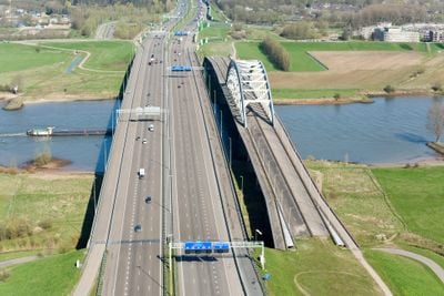
The Jan Blankenbrug is a modern bridge that crosses the Lek River between Vianen and Nieuwegein. It consists of two parallel concrete structures that together span approximately 530 meters.

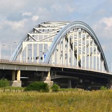
A steel arch bridge originally stood at this location, built between 1934 and 1936 and damaged during World War II. It was later replaced by the current concrete structure to handle increasing traffic flow.

The bridge bears the name of Jan Blanken, the first Inspector-General of Water Management who shaped Dutch infrastructure in the late 18th century.

The bridge is divided into two separate roadways with six lanes total and connects both sides of the river directly. Pedestrians and cyclists can use it, but should be aware of heavy traffic, especially during peak times.

The structure uses a special design without support piers in the river, allowing one of the widest free spans in Europe. This technique keeps river traffic unobstructed while ensuring a stable crossing.

The community of curious travelers

AroundUs brings together thousands of curated places, local tips, and hidden gems, enriched daily by 60,000 contributors worldwide.

Start exploring
Location
Location
Location
GPS coordinates
51.99778,5.07833
Latest update
December 14, 2025 13:01
Around this place
Lekbrug
Netherlands

Lekbrug

0 m
Castle Batenstein
Netherlands

Castle Batenstein

939 m
O.L. Vrouw ten Hemelopneming, Vianen
Netherlands

O.L. Vrouw ten Hemelopneming, Vianen

890 m
Watertoren
Netherlands

Watertoren

843 m
Lekpoort
Netherlands

Lekpoort

942 m
In het pand of op de grens van het erf bevindende stadsmuur(resten)
Netherlands

In het pand of op de grens van het erf bevindende stadsmuur(resten)

893 m
In het pand of op de grens van het erf bevindende stadsmuur(resten)
Netherlands

In het pand of op de grens van het erf bevindende stadsmuur(resten)

915 m
In het pand of op de grens van het erf bevindende stadsmuur(resten)
Netherlands

In het pand of op de grens van het erf bevindende stadsmuur(resten)

942 m
In het pand of op de grens van het erf bevindende stadsmuur(resten)
Netherlands

In het pand of op de grens van het erf bevindende stadsmuur(resten)

925 m
Kortendijk 6, Vianen
Netherlands

Kortendijk 6, Vianen

921 m
Kortendijk 8, Vianen
Netherlands

Kortendijk 8, Vianen

919 m
Voorstraat 1, Vianen
Netherlands

Voorstraat 1, Vianen

937 m
Hofpoort (Vianen)
Netherlands

Hofpoort (Vianen)

804 m
Hofplein 30, Vianen
Netherlands

Hofplein 30, Vianen

793 m
Vroeg 19e-eeuws pand met lijstgevel
Netherlands

Vroeg 19e-eeuws pand met lijstgevel

906 m
Kortendijk 9, Vianen
Netherlands

Kortendijk 9, Vianen

903 m
Voorstraat 3, Vianen
Netherlands

Voorstraat 3, Vianen

940 m
Kortendijk 5, Vianen
Netherlands

Kortendijk 5, Vianen

915 m
In het pand of op de grens van het erf bevindende stadsmuur(resten)
Netherlands

In het pand of op de grens van het erf bevindende stadsmuur(resten)

921 m
Kortendijk 3, Vianen
Netherlands

Kortendijk 3, Vianen

921 m
Villagepump, Vianen
Netherlands

Villagepump, Vianen

804 m
Brederodestraat 1, Vianen
Netherlands

Brederodestraat 1, Vianen

853 m
Wallen met overblijfselen van de stadsmuren aan de Zuidzijde van de stad met het watervlak van binnen en buitengracht
Netherlands

Wallen met overblijfselen van de stadsmuren aan de Zuidzijde van de stad met het watervlak van binnen en buitengracht

846 m
Gedeelte van het watervlak van de buitengracht
Netherlands

Gedeelte van het watervlak van de buitengracht

663 m
Hofplein 36, Vianen
Netherlands

Hofplein 36, Vianen

765 m
Dwarshuis van alleen beganegrond met empire-ramen en deurpartij met bovenlicht
Netherlands

Dwarshuis van alleen beganegrond met empire-ramen en deurpartij met bovenlicht

786 m
Filtergebouw, Watertoren Vianen
Netherlands

Filtergebouw, Watertoren Vianen

859 m
Hofplein 2, Vianen
Netherlands

Hofplein 2, Vianen

888 m
Show the full map
Reviews
Share your experience

No review yet

Discussions
Start a discussion...

No discussion yet

« Jan Blankenbrug - Transportation bridge across Lek River in Utrecht Province, Netherlands » is provided by Around Us (aroundus.com). Images and texts are derived from Wikimedia project under a Creative Commons license. You are allowed to copy, distribute, and modify copies of this page, under the conditions set by the license, as long as this note is clearly visible.

Discover hidden gems everywhere you go!

From secret cafés to breathtaking viewpoints, skip the crowded tourist spots and find places that match your style. Our app makes it easy with voice search, smart filtering, route optimization, and insider tips from travelers worldwide. Download now for the complete mobile experience.

Around Us App Screenshot

A unique approach to discovering new places

Le Figaro

All the places worth exploring

France Info

A tailor-made excursion in just a few clicks

20 Minutes

Around Us
Travel Guide & Maps
Download

Send to your phone

QR Code
1

Open the camera app on your mobile.

2

Point at the QR code with your camera. A notification will appear.

3

Tap the notification to open the link.