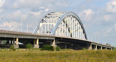
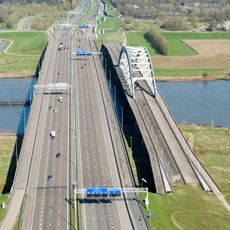
Lekbrug, Steel bridge between Vianen and Nieuwegein, Netherlands
The Lekbrug is a steel bridge that spans the Lek River between Vianen and Nieuwegein with a characteristic steel framework construction. It features separate lanes for vehicles and pedestrians, providing a key connection between these two communities in Utrecht province.
The bridge was constructed in 1936 as part of the expanding Dutch road network, and it suffered damage during World War II. It was reconstructed in the early 1950s and became part of the A2 highway system.
The bridge serves as a daily crossing for local residents and has become a familiar landmark in the region's landscape. It represents the practical relationship between the two communities separated by the river.
The bridge is straightforward to use by car and on foot since each type of traffic has its own separate path. Crossing is well marked and can be done in any direction without needing special arrangements or equipment.
The original 1936 structure still stands alongside newer bridges built in the 1990s, creating an unusual side-by-side view of engineering from different eras. This coexistence shows how transportation solutions evolved over the decades in this crossing.
Location: Vianen
Location: Nieuwegein
Inception: 1936
GPS coordinates: 51.99778,5.07833
Latest update: December 10, 2025 20:01
Castle Batenstein
939 m
Jan Blankenbrug
0 m
O.L. Vrouw ten Hemelopneming, Vianen
890 m
Watertoren
843 m
Lekpoort
942 m
In het pand of op de grens van het erf bevindende stadsmuur(resten)
893 m
In het pand of op de grens van het erf bevindende stadsmuur(resten)
915 m
In het pand of op de grens van het erf bevindende stadsmuur(resten)
942 m
In het pand of op de grens van het erf bevindende stadsmuur(resten)
925 m
Kortendijk 6, Vianen
921 m
Kortendijk 8, Vianen
919 m
Voorstraat 1, Vianen
937 m
Hofpoort (Vianen)
804 m
Hofplein 30, Vianen
793 m
Vroeg 19e-eeuws pand met lijstgevel
906 m
Kortendijk 9, Vianen
903 m
Voorstraat 3, Vianen
940 m
Kortendijk 5, Vianen
915 m
In het pand of op de grens van het erf bevindende stadsmuur(resten)
921 m
Kortendijk 3, Vianen
921 m
Villagepump, Vianen
804 m
Brederodestraat 1, Vianen
853 m
Wallen met overblijfselen van de stadsmuren aan de Zuidzijde van de stad met het watervlak van binnen en buitengracht
846 m
Gedeelte van het watervlak van de buitengracht
663 m
Hofplein 36, Vianen
765 m
Dwarshuis van alleen beganegrond met empire-ramen en deurpartij met bovenlicht
786 m
Filtergebouw, Watertoren Vianen
859 m
Hofplein 2, Vianen
888 mVisited this place? Tap the stars to rate it and share your experience / photos with the community! Try now! You can cancel it anytime.
Discover hidden gems everywhere you go!
From secret cafés to breathtaking viewpoints, skip the crowded tourist spots and find places that match your style. Our app makes it easy with voice search, smart filtering, route optimization, and insider tips from travelers worldwide. Download now for the complete mobile experience.
A unique approach to discovering new places❞
— Le Figaro
All the places worth exploring❞
— France Info
A tailor-made excursion in just a few clicks❞
— 20 Minutes