Hellevoetsluis Lighthouse

Log in to your account

AroundUs is a community-driven map of interesting places, built by curious explorers like you. It grows with every review, story, and photo you share.
Connect to save your favorite spots, contribute locations, and create personalized routes.
Continue with Google
Continue with Apple
Continue with X
Continue with Facebook
Continue with email
By continuing, you accept our Terms and Conditions and our Privacy Policy
Create an account

Hellevoetsluis Lighthouse

Add to collection
Map
Suggest a change
Share

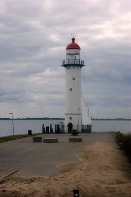
Hellevoetsluis Lighthouse, Maritime lighthouse in Hellevoetsluis, Netherlands

Hellevoetsluis Lighthouse is a brick tower on the Dutch coast that rises 18.1 meters high and features white markings with a red roof. The structure continues to function as an active navigational aid for ships entering the harbor today.

The lighthouse was built in 1822 to replace a simpler lighting system that proved inadequate for guiding ships safely into harbor. Since its construction, it has served generations of sailors and remains a key landmark in the region's maritime history.

The structure takes its name from the town of Hellevoetsluis and reflects the long relationship between this settlement and maritime activity. Visitors can see how the lighthouse remains woven into daily harbor life, showing how people here have connected with the sea for generations.

The lighthouse sits on the Voorne aan Zee coast and can be viewed from outside, though it remains an active navigational facility. Visitors should know that the tower is still in operation and may not always be open for public access.

The tower survived a planned demolition in 1951 only because local residents strongly opposed it, recognizing the structure as valuable to their community. This event shows how deeply people viewed the building as part of their local identity.

Location: Voorne aan Zee

Inception: 1822

Floors above the ground: 2

Height: 18.1 m

Made from material: brick

Address: Westkade 1, 3221AV Hellevoetsluis

GPS coordinates: 51.81972,4.12778

Latest update: December 14, 2025 14:21

Photos
Reviews

Visited this place? Tap the stars to rate it and share your experience / photos with the community! Try now! You can cancel it anytime.

« Hellevoetsluis Lighthouse - Maritime lighthouse in Hellevoetsluis, Netherlands » is provided by Around Us (aroundus.com). Images and texts are derived from Wikimedia project under a Creative Commons license. You are allowed to copy, distribute, and modify copies of this page, under the conditions set by the license, as long as this note is clearly visible.

Discover hidden gems everywhere you go!

From secret cafés to breathtaking viewpoints, skip the crowded tourist spots and find places that match your style. Our app makes it easy with voice search, smart filtering, route optimization, and insider tips from travelers worldwide. Download now for the complete mobile experience.

Around Us App Screenshot

A unique approach to discovering new places

Le Figaro

All the places worth exploring

France Info

A tailor-made excursion in just a few clicks

20 Minutes