Enable Location

We need your location to show you interesting places around you

Discover nearby places

Find interesting locations and hidden gems around you

Precise directions

Get accurate directions and distances to places

Your location is never shared with other users. It's only used when you tap the location button.

Bouçã Dam

Log in to your account

Start exploring — it's free

Trusted by 62,057 travelers worldwide

Continue with Google
Continue with Apple
or

We will send you a code to connect

By continuing, you accept our Terms and Conditions and our Privacy Policy

Check your inbox

We've sent a pincode in your inbox. Please enter the code below.

Bouçã Dam

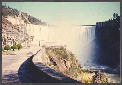
Bouçã Dam, Hydroelectric power station in Leiria, Portugal.

Bouçã Dam is a concrete arch structure that holds back water in the Zêzere River valley for power generation purposes. The facility operates with two turbine units housed within the dam, managed by control systems that regulate water flow through the structure.

The structure was inaugurated in 1955 as part of Portugal's efforts to develop hydroelectric power generation capacity. This period was driven by industrial growth and the need to build more reliable energy sources across the nation.

The dam represents Portuguese engineering expertise in renewable energy, contributing to the region's shift toward sustainable power generation methods.

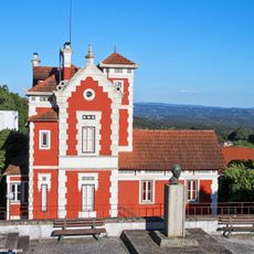
Visitors can explore the site during daylight hours, with several viewpoints along the dam offering good views of the structure. Access is generally free, though it is wise to check conditions before arriving, as water levels can affect visibility of certain features.

The reservoir behind the structure experiences varying water levels throughout the year depending on seasonal patterns and energy needs, which creates a constantly changing appearance. These natural fluctuations affect how much of the dam face remains visible at different times.

The community of curious travelers

AroundUs brings together thousands of curated places, local tips, and hidden gems, enriched daily by 60,000 contributors worldwide.

Start exploring
Location
Elevation above the sea
175 m
GPS coordinates
39.85306,-8.21972
Latest update
December 12, 2025 16:42
Around this place
Casulo
Portugal

Casulo

7.3 km
Bairradas
Portugal

Bairradas

2.1 km
Igreja de São João Baptista, paroquial de Figueiró dos Vinhos
Portugal

Igreja de São João Baptista, paroquial de Figueiró dos Vinhos

7.2 km
Tribunal Judicial de Figueiró dos Vinhos
Portugal

Tribunal Judicial de Figueiró dos Vinhos

7.3 km
Edifício dos Correios, Telégrafos e Telefones, CTT, de Figueiró dos Vinhos
Portugal

Edifício dos Correios, Telégrafos e Telefones, CTT, de Figueiró dos Vinhos

7.3 km
Chalet na Rua Dr. Manuel Simões Barreiros, n.º 60
Portugal

Chalet na Rua Dr. Manuel Simões Barreiros, n.º 60

7.3 km
Clube Figueiroense
Portugal

Clube Figueiroense

7.3 km
Edifício F. R. Ferreira - Lanifícios
Portugal

Edifício F. R. Ferreira - Lanifícios

7.4 km
Parque Municipal de Figueiró dos Vinhos
Portugal

Parque Municipal de Figueiró dos Vinhos

7.2 km
Igreja Paroquial da Graça
Portugal

Igreja Paroquial da Graça

4.6 km
Torre da Cadeia de Figueiró dos Vinhos
Portugal

Torre da Cadeia de Figueiró dos Vinhos

7.4 km
Convento de Nossa Senhora do Carmo dos Carmelitas Descalços, incluindo a Igreja e construções anexas
Portugal

Convento de Nossa Senhora do Carmo dos Carmelitas Descalços, incluindo a Igreja e construções anexas

7 km
Câmara Municipal de Figueiró dos Vinhos
Portugal

Câmara Municipal de Figueiró dos Vinhos

7.3 km
Cerca do Convento de Nossa Senhora do Carmo dos Carmelitas Descalços
Portugal

Cerca do Convento de Nossa Senhora do Carmo dos Carmelitas Descalços

7.1 km
Fonte dos Amores
Portugal

Fonte dos Amores

7.2 km
Capela de São Vicente
Portugal

Capela de São Vicente

7.5 km
Cruz de Ferro em Figueiró dos Vinhos
Portugal

Cruz de Ferro em Figueiró dos Vinhos

7.5 km
Casa Simões de Almeida
Portugal

Casa Simões de Almeida

7.3 km
Jardim Municipal de Figueiró dos Vinhos
Portugal

Jardim Municipal de Figueiró dos Vinhos

7.3 km
Casa de Santo António dos Milagres
Portugal

Casa de Santo António dos Milagres

7.4 km
Santuário de Nossa Senhora dos Remédios
Portugal

Santuário de Nossa Senhora dos Remédios

7.5 km
Solar de Figueiró dos Vinhos
Portugal

Solar de Figueiró dos Vinhos

7.3 km
Casa Solar das Freiras
Portugal

Casa Solar das Freiras

7.4 km
Fonte das Freiras
Portugal

Fonte das Freiras

7.5 km
Casa do Povo em Figueiró dos Vinhos
Portugal

Casa do Povo em Figueiró dos Vinhos

7.2 km
Casa na Rua da Palmeira, n..º 9
Portugal

Casa na Rua da Palmeira, n..º 9

7.2 km
Casa na Rua Dr. António José de Almeida, n.º 101
Portugal

Casa na Rua Dr. António José de Almeida, n.º 101

7.5 km
Casa na Praça do Munícipio, n.º 2 a 8
Portugal

Casa na Praça do Munícipio, n.º 2 a 8

7.3 km
Show the full map
« Bouçã Dam - Hydroelectric power station in Leiria, Portugal » is provided by Around Us (aroundus.com). Images and texts are derived from Wikimedia project under a Creative Commons license. You are allowed to copy, distribute, and modify copies of this page, under the conditions set by the license, as long as this note is clearly visible.

Discover hidden gems everywhere you go!

From secret cafés to breathtaking viewpoints, skip the crowded tourist spots and find places that match your style. Our app makes it easy with voice search, smart filtering, route optimization, and insider tips from travelers worldwide. Download now for the complete mobile experience.

Around Us App Screenshot

A unique approach to discovering new places

Le Figaro

All the places worth exploring

France Info

A tailor-made excursion in just a few clicks

20 Minutes

Around Us
Travel Guide & Maps
Download

Send to your phone

QR Code
1

Open the camera app on your mobile.

2

Point at the QR code with your camera. A notification will appear.

3

Tap the notification to open the link.