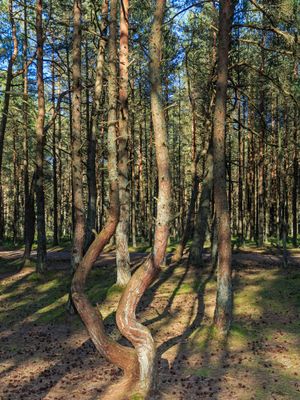
Dancing Forest, Pine forest on the Curonian Spit, Russia.
Dancing Forest is a pine forest on the Curonian Spit where dozens of trees have trunks that form unusual shapes like circles, loops, and spirals. The area features a network of trails that wind between these twisted pines, allowing visitors to walk among the strange formations.
The pines were planted in the 1960s to stabilize the moving sand dunes and replaced a former German gliding school that had operated before World War II. This reforestation effort turned the area from an aviation site into the forest that exists today.
Local stories tell of trees that began dancing to show divine power, and many visitors touch the trunk rings hoping to make a wish. The legends are deeply rooted in how people experience walking through the rows of bent pines.
The forest is accessible year-round and works well for walks and photography, with the best light for photos usually in early morning or late afternoon. The trails are relatively flat and easy to walk, but visitors should wear proper footwear and bring protection against insects.
Scientific studies suggest the twisted growth patterns might be caused by caterpillar activity from the moth species Rhyacionia buoliana or by sand dune movement itself. Despite decades of research, the exact cause of the contorted trunks remains unsolved, making the forest feel like a genuine mystery.
The community of curious travelers
AroundUs brings together thousands of curated places, local tips, and hidden gems, enriched daily by 60,000 contributors worldwide.