Gunnarp 49:1, röse i Halland
Location: Falkenberg Municipality
GPS coordinates: 57.16308,12.93113
Latest update: November 3, 2025 01:08
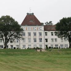
Fagereds sanatorium
8.6 km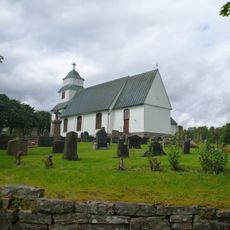
Gunnarps kyrka
1.7 km
Mårdaklev 18:1
7.9 km
Gunnarp 111:1
5.5 km
Mårdaklev 14:1
2.2 km
Konungadal
904 m
Gunnarp 38:1
595 m
Gunnarp 35:1
439 m
Gunnarp 43:1
1.7 km
Mårdaklev 23:3
8.3 km
Gunnarp 34:1
438 m
Drottningrör
4.9 km
Gunnarp 33:1
882 m
Gunnarp 15:1
4.9 km
Kalv 15:1
8.3 km
Gunnarp 39:1
552 m
Gunnarp 42:1
1.1 km
Gällared 135
8.5 km
Gunnarp 35:2
424 m
Mårdaklev 9:1
1.6 km
Mårdaklev 11:1
1.7 km
Gunnarp 61:1
464 m
Mårdaklev 17:1
8.1 km
Gunnarp 2:1
5 km
Mårdaklev 19:1
7.8 km
Mårdaklev 23:2
8.4 km
Gunnarp 37:1
623 m
Kalv 75:1
8.4 kmReviews
Visited this place? Tap the stars to rate it and share your experience / photos with the community! Try now! You can cancel it anytime.
Discover hidden gems everywhere you go!
From secret cafés to breathtaking viewpoints, skip the crowded tourist spots and find places that match your style. Our app makes it easy with voice search, smart filtering, route optimization, and insider tips from travelers worldwide. Download now for the complete mobile experience.

A unique approach to discovering new places❞
— Le Figaro
All the places worth exploring❞
— France Info
A tailor-made excursion in just a few clicks❞
— 20 Minutes