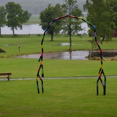
2) S:t Olofs valar, röse i Bohuslän (Klövedal 40:1)
Location: Tjörn Municipality
GPS coordinates: 58.01552,11.51957
Latest update: October 25, 2025 19:14
Pilane sculpture park
2.7 km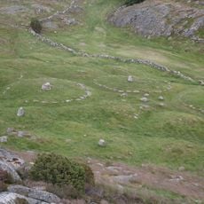
Pilane
2.6 km
Härön
1.7 km
Stenkyrka 183:1
1.9 km
Klövedal 43:1
377 m
Klövedal 14:1
2.4 km
Linnevikens, public beach
274 m
Storrös
2.7 km
Klövedal 62:1
2.3 km
Klövedal 66:1
1 km
Stenkyrka 178:1
2.1 km
Klövedal 91:2
1.2 km
Klövedal 91:1
1.2 km
Klövedal 61:1
2.3 km
Klövedal 41:1
283 m
Klövedal 44:1
348 m
Klövedal 89:1
1.3 km
Klövedal 60:1
2.7 km
Klövedal 59:1
2.6 km
Klövedal 91:4
1.2 km
Klövedal 33:1
1.1 km
Gröterös
1.7 km
Klövedal 18:1
2.3 km
ANNA
2.5 km
Pilane
2.5 km
Work of art, sculpture
1.1 km
Sankt Olovs valar
12 m
Scenic viewpoint
2.5 kmReviews
Visited this place? Tap the stars to rate it and share your experience / photos with the community! Try now! You can cancel it anytime.
Discover hidden gems everywhere you go!
From secret cafés to breathtaking viewpoints, skip the crowded tourist spots and find places that match your style. Our app makes it easy with voice search, smart filtering, route optimization, and insider tips from travelers worldwide. Download now for the complete mobile experience.

A unique approach to discovering new places❞
— Le Figaro
All the places worth exploring❞
— France Info
A tailor-made excursion in just a few clicks❞
— 20 Minutes